
Ferral topographic map
Interactive map
Click on the map to display elevation.
About this map
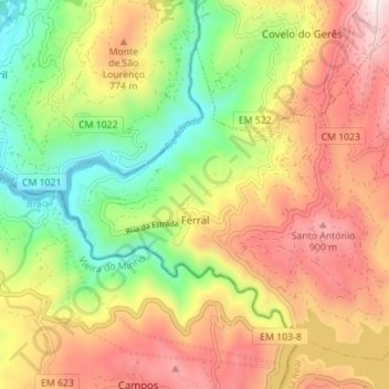
Name: Ferral topographic map, elevation, terrain.
Location: Ferral, Montalegre, Vila Real, 5470-122, Portugal (41.67553 -8.02341 41.71981 -7.95377)
Average elevation: 2,014 ft
Minimum elevation: 850 ft
Maximum elevation: 3,241 ft
Other topographic maps
Click on a map to view its topography, its elevation and its terrain.
Garganta das Negras
Portugal > Vila Real > Montalegre > Outeiro
Garganta das Negras, Outeiro, Montalegre, Vila Real, Portugal
Average elevation: 4,416 ft
Padrões
Portugal > Vila Real > Montalegre
Padrões, Venda Nova e Pondras, Montalegre, Vila Real, 5470-504, Portugal
Average elevation: 2,520 ft
Vilar de Perdizes
Portugal > Vila Real > Montalegre
Vilar de Perdizes, Montalegre, Vila Real, Portugal
Average elevation: 2,598 ft
Aldeia Nova do Barroso
Portugal > Vila Real > Montalegre > Chã
Aldeia Nova do Barroso, Chã, Montalegre, Vila Real, 5470-071, Portugal
Average elevation: 2,949 ft
Pitões das Junias
Portugal > Vila Real > Montalegre
Pitões das Junias, Montalegre, Vila Real, 5470-370, Portugal
Average elevation: 3,802 ft
Tourém
Portugal > Vila Real > Montalegre
Tourém, Montalegre, Vila Real, Portugal
Average elevation: 3,366 ft