Geolocate

Vilar de Perdizes topographic map

Interactive map

Click on the map to display elevation.

About this map

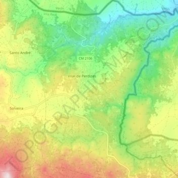
Name: Vilar de Perdizes topographic map, elevation, terrain.

Location: Vilar de Perdizes, Montalegre, Vila Real, Portugal (41.81649 -7.65777 41.88509 -7.58330)

Average elevation: 2,598 ft

Minimum elevation: 1,854 ft

Maximum elevation: 3,698 ft

Other topographic maps

Click on a map to view its topography, its elevation and its terrain.

Garganta das Negras

Portugal > Vila Real > Montalegre > Outeiro

Garganta das Negras, Outeiro, Montalegre, Vila Real, Portugal

Average elevation: 4,416 ft

Padrões

Portugal > Vila Real > Montalegre

Padrões, Venda Nova e Pondras, Montalegre, Vila Real, 5470-504, Portugal

Average elevation: 2,520 ft

Ferral

Portugal > Vila Real > Montalegre

Ferral, Montalegre, Vila Real, 5470-122, Portugal

Average elevation: 2,014 ft

Aldeia Nova do Barroso

Portugal > Vila Real > Montalegre > Chã

Aldeia Nova do Barroso, Chã, Montalegre, Vila Real, 5470-071, Portugal

Average elevation: 2,949 ft

Pitões das Junias

Portugal > Vila Real > Montalegre

Pitões das Junias, Montalegre, Vila Real, 5470-370, Portugal

Average elevation: 3,802 ft

Tourém

Portugal > Vila Real > Montalegre

Tourém, Montalegre, Vila Real, Portugal

Average elevation: 3,366 ft