
Make a donation
Gear up for your next adventure:
As an Amazon Associate, this site earns from qualifying purchases at no extra cost to you.
Havens Corners topographic map
Click on the map to display elevation.
Make a donation
Gear up for your next adventure:
As an Amazon Associate, this site earns from qualifying purchases at no extra cost to you.
About this map
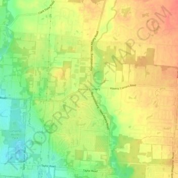
Name: Havens Corners topographic map, elevation, terrain.
Average elevation: 971 ft
Minimum elevation: 873 ft
Maximum elevation: 1,043 ft
Franklin County trails, hiking, mountain biking, running and outdoor activities
Make a donation
Gear up for your next adventure:
As an Amazon Associate, this site earns from qualifying purchases at no extra cost to you.
Other topographic maps
Click on a map to view its topography, its elevation and its terrain.
Blacklick Estates
United States > Ohio > Franklin County > Blacklick Estates
Average elevation: 755 ft
Make a donation
Gear up for your next adventure:
As an Amazon Associate, this site earns from qualifying purchases at no extra cost to you.
Make a donation
Gear up for your next adventure:
As an Amazon Associate, this site earns from qualifying purchases at no extra cost to you.
Make a donation
Gear up for your next adventure:
As an Amazon Associate, this site earns from qualifying purchases at no extra cost to you.
Jefferson Township
United States > Ohio > Franklin County
Blacklick Creek and its associated tributaries of its watershed such as Swisher Creek flow through Jefferson Township. Big Walnut Creek is also to the west of the township while some of its tributaries such as Rocky Fork Creek travel through the western part of Jefferson Township. This has caused the…
Average elevation: 961 ft
Make a donation
Gear up for your next adventure:
As an Amazon Associate, this site earns from qualifying purchases at no extra cost to you.
Pickerington Ponds Metro Park
United States > Ohio > Franklin County > Columbus
Average elevation: 791 ft
Make a donation
Gear up for your next adventure:
As an Amazon Associate, this site earns from qualifying purchases at no extra cost to you.
Edward S. Thomas Nature Preserve
United States > Ohio > Franklin County > Columbus
Average elevation: 902 ft
Make a donation
Gear up for your next adventure:
As an Amazon Associate, this site earns from qualifying purchases at no extra cost to you.