Geolocate

Byron topographic map

Click on the map to display elevation.

About this map

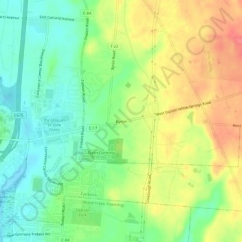
Name: Byron topographic map, elevation, terrain.

Location: Byron, Bath Township, Greene County, Ohio, 45324, United States (39.76617 -84.00077 39.80617 -83.96077)

Average elevation: 919 ft

Minimum elevation: 823 ft

Maximum elevation: 1,040 ft

Greene County trails, hiking, mountain biking, running and outdoor activities

Other topographic maps

Click on a map to view its topography, its elevation and its terrain.

Beavercreek Township

United States > Ohio > Greene County

Average elevation: 883 ft

Spring Valley

United States > Ohio > Greene County

Average elevation: 827 ft

Clifton

United States > Ohio > Greene County

Average elevation: 1,024 ft

Twin Towers County Park

United States > Ohio > Greene County

Average elevation: 1,007 ft

Bowersville

United States > Ohio > Greene County

Average elevation: 1,079 ft

Ross Township

United States > Ohio > Greene County

Average elevation: 1,083 ft

Bellbrook

United States > Ohio > Greene County

Average elevation: 860 ft

Gear up for your next adventure:

🧭Pro Hiking Compasses - High-accuracy liquid-filled compasses for topographic orientation
🎁Geography Themed Gifts - Unique gift ideas for map lovers and geography enthusiasts
🌧️Backpack Rain Cover - Keep gear dry in wet weather
📖Nature Tracking Books - Learn to track wildlife and terrain
🦺Reflective Outdoor Gear - Safety gear for low‑light conditions

As an Amazon Associate, this site earns from qualifying purchases at no extra cost to you.