
Mineral topographic map
Click on the map to display elevation.
About this map
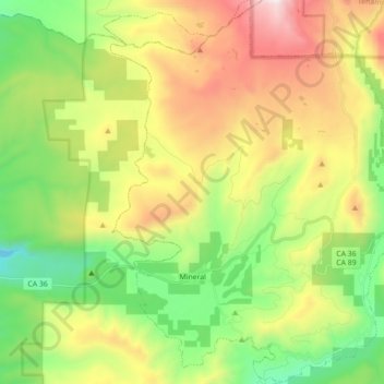
Name: Mineral topographic map, elevation, terrain.
Location: Mineral, Tehama County, California, 96063, United States (40.30922 -121.64008 40.44337 -121.50154)
Average elevation: 5,748 ft
Minimum elevation: 3,743 ft
Maximum elevation: 8,812 ft
Tehama County trails, hiking, mountain biking, running and outdoor activities
Other topographic maps
Click on a map to view its topography, its elevation and its terrain.
Gerber
United States > California > Tehama County
Gerber is a census-designated place (CDP) in Tehama County, California. Gerber sits at an elevation of 226 feet (69 m). The 2020 United States census reported Gerber's population was 1,044.
Average elevation: 236 ft