
Make a donation
Gear up for your next adventure:
As an Amazon Associate, this site earns from qualifying purchases at no extra cost to you.
Kamiah topographic map
Click on the map to display elevation.
Make a donation
Gear up for your next adventure:
As an Amazon Associate, this site earns from qualifying purchases at no extra cost to you.
Kamiah
The city is located at the confluence of Lawyer Creek and the Clearwater River on the left bank of the latter. In the Kamiah area, the Lewis-Idaho County line follows Lawyer Creek to its confluence with the Clearwater, and then turns to follow the Clearwater. U.S. Route 12 passes through Kamiah, crossing from the right to left bank of the Clearwater at the city. The two streams cut deep and narrow valleys through the otherwise relatively flat, rolling Camas Prairie region that surrounds Kamiah. The city is located at 1,250 feet above sea level, but elevations of over 2,800 feet on the prairie lie within three miles of Kamiah.
Make a donation
Gear up for your next adventure:
As an Amazon Associate, this site earns from qualifying purchases at no extra cost to you.
About this map
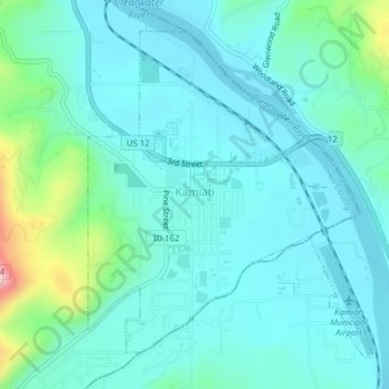
Name: Kamiah topographic map, elevation, terrain.
Location: Kamiah, Lewis County, Idaho, 83536, United States (46.21557 -116.03977 46.23825 -116.01111)
Average elevation: 1,309 ft
Minimum elevation: 1,148 ft
Maximum elevation: 2,057 ft
Lewis County trails, hiking, mountain biking, running and outdoor activities
Make a donation
Gear up for your next adventure:
As an Amazon Associate, this site earns from qualifying purchases at no extra cost to you.