Geolocate

Red Bluff topographic map

Click on the map to display elevation.

About this map

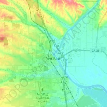
Name: Red Bluff topographic map, elevation, terrain.

Location: Red Bluff, Tehama County, California, 96080, United States (40.13510 -122.26641 40.23084 -122.19682)

Average elevation: 338 ft

Minimum elevation: 243 ft

Maximum elevation: 577 ft

Tehama County trails, hiking, mountain biking, running and outdoor activities

Other topographic maps

Click on a map to view its topography, its elevation and its terrain.

Loybas Hill

United States > California > Tehama County

Average elevation: 197 ft

Gerber

United States > California > Tehama County

Gerber is a census-designated place (CDP) in Tehama County, California. Gerber sits at an elevation of 226 feet (69 m). The 2020 United States census reported Gerber's population was 1,044.

Average elevation: 236 ft

Beegum Peak

United States > California > Tehama County

Average elevation: 3,018 ft

Corning

United States > California > Tehama County

Average elevation: 282 ft

Gear up for your next adventure:

🛰️Handheld GPS Units - Professional satellite navigators for precise backcountry mapping
🪶Camping Sleeping Pad - Comfortable sleeping pad for backpacking
🩹Survival Bandages - High‑quality bandages for emergencies
📡GPS Antenna Upgrade - Enhance GPS reception in remote terrain
📶Vehicle Signal Boosters - Improve reception in rural areas while driving to trailheads

As an Amazon Associate, this site earns from qualifying purchases at no extra cost to you.