Geolocate

Bearsted topographic map

Click on the map to display elevation.

About this map

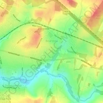
Name: Bearsted topographic map, elevation, terrain.

Location: Bearsted, Maidstone, Kent, England, United Kingdom (51.26163 0.55699 51.27689 0.59154)

Average elevation: 187 ft

Minimum elevation: 82 ft

Maximum elevation: 292 ft

Other topographic maps

Click on a map to view its topography, its elevation and its terrain.

Walderslade Woods

United Kingdom > England > Kent > Maidstone

Average elevation: 509 ft

Westfield Sole

United Kingdom > England > Kent > Maidstone

Average elevation: 476 ft

Detling Hill

United Kingdom > England > Kent > Maidstone

Average elevation: 499 ft

Mote Park

United Kingdom > England > Kent > Maidstone > Otham

Average elevation: 171 ft

Broomfield

United Kingdom > England > Kent > Maidstone > Leeds

Average elevation: 315 ft

Lenham Heath

United Kingdom > England > Kent > Maidstone

Average elevation: 315 ft

Leadingcross Green

United Kingdom > England > Kent > Maidstone > Lenham

Average elevation: 387 ft

Harpole

United Kingdom > England > Kent > Maidstone > Detling

Average elevation: 338 ft

Bletchenden

United Kingdom > England > Kent > Maidstone > Headcorn

Average elevation: 79 ft

Liverton Street

United Kingdom > England > Kent > Maidstone > Grafty Green

Average elevation: 335 ft

Linton

United Kingdom > England > Kent > Maidstone

Average elevation: 233 ft

East Lenham

United Kingdom > England > Kent > Maidstone > Lenham

Average elevation: 417 ft

Bicknor Wood

United Kingdom > England > Kent > Maidstone > Otham

Average elevation: 279 ft

Laddingford

United Kingdom > England > Kent > Maidstone > Yalding

Average elevation: 46 ft

Langley Park

United Kingdom > England > Kent > Maidstone > Langley

Average elevation: 315 ft

Bletchingly

United Kingdom > England > Kent > Maidstone

Average elevation: 121 ft

Weavering Park

United Kingdom > England > Kent > Maidstone > Grove Green

Average elevation: 184 ft

Eyhorne Street

United Kingdom > England > Kent > Maidstone > Hollingbourne

Average elevation: 295 ft

Kingswood

United Kingdom > England > Kent > Maidstone

Average elevation: 358 ft

Gear up for your next adventure:

📻Weather Alert Radios - Stay informed of storm risks while off-the-grid
💧Water Filtration Bottles - Safely drink from streams and lakes while exploring
🔭Compact Binoculars - HD vision for scouting terrain and identifying distant landmarks
🧭Hiking Compass - Precision compass for reliable navigation in the wilderness
🛠️Outdoor Gear Repair Kit - Essential tools to fix gear on the trail

As an Amazon Associate, this site earns from qualifying purchases at no extra cost to you.