
Town of Amenia topographic map
Interactive map
Click on the map to display elevation.
About this map
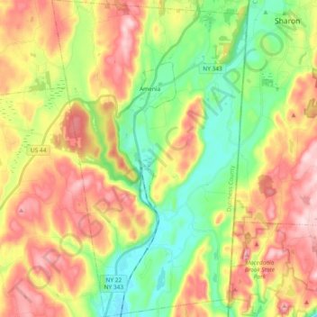
Name: Town of Amenia topographic map, elevation, terrain.
Location: Town of Amenia, Dutchess County, New York, United States (41.74995 -73.61480 41.88828 -73.50010)
Average elevation: 840 ft
Minimum elevation: 384 ft
Maximum elevation: 1,411 ft
Other topographic maps
Click on a map to view its topography, its elevation and its terrain.
United States of America Property
United States > New York > Dutchess County > Village of Pawling
United States of America Property, West Dover Road, Village of Pawling, Town of Pawling, Town of Dover, Dutchess County, New York, 12564, United States
Average elevation: 823 ft
Town of Pawling
United States > New York > Dutchess County
Town of Pawling, Dutchess County, New York, United States
Average elevation: 797 ft
Titusville
United States > New York > Dutchess County
Titusville, Town of La Grange, Dutchess County, New York, United States
Average elevation: 213 ft
Clinton Corners
United States > New York > Dutchess County
Clinton Corners, Town of Clinton, Dutchess County, New York, 12514, United States
Average elevation: 374 ft
City of Beacon
United States > New York > Dutchess County
City of Beacon, Dutchess County, New York, 12508, United States
Average elevation: 223 ft
Town of Beekman
United States > New York > Dutchess County
Town of Beekman, Dutchess County, New York, 12570, United States
Average elevation: 636 ft
Shorehaven
United States > New York > Dutchess County > Town of Pawling
Shorehaven, Town of Pawling, Dutchess County, New York, United States
Average elevation: 958 ft
Barrytown
United States > New York > Dutchess County > Town of Red Hook
Barrytown, Town of Red Hook, Dutchess County, New York, 12507, United States
Average elevation: 85 ft
Bangall
United States > New York > Dutchess County
Bangall, Town of Stanford, Dutchess County, New York, 12506, United States
Average elevation: 564 ft
Leedsville
United States > New York > Dutchess County > Town of Amenia
Leedsville, Town of Amenia, Dutchess County, New York, 12501, United States
Average elevation: 627 ft
Rhinecliff
United States > New York > Dutchess County > Town of Rhinebeck
Rhinecliff, Town of Rhinebeck, Dutchess County, New York, 12574, United States
Average elevation: 62 ft
Sharon Station
United States > New York > Dutchess County
Sharon Station, Town of North East, Dutchess County, New York, 12501, United States
Average elevation: 676 ft
South Amenia
United States > New York > Dutchess County > Town of Amenia
South Amenia, Town of Amenia, Dutchess County, New York, 12592, United States
Average elevation: 610 ft
Annandale-on-Hudson
United States > New York > Dutchess County > Town of Red Hook
Annandale-on-Hudson, Town of Red Hook, Dutchess County, New York, 12504, United States
Average elevation: 141 ft
Myers Corner
United States > New York > Dutchess County
Myers Corner, Town of Wappinger, Dutchess County, New York, 12590, United States
Average elevation: 246 ft
Timothy Heights
United States > New York > Dutchess County > Town of Pleasant Valley
Timothy Heights, Town of Pleasant Valley, Dutchess County, New York, 12569, United States
Average elevation: 285 ft
Bulls Head
United States > New York > Dutchess County
Bulls Head, Town of Clinton, Dutchess County, New York, 12514, United States
Average elevation: 492 ft
Village of Tivoli
United States > New York > Dutchess County
Village of Tivoli, Town of Red Hook, Dutchess County, New York, United States
Average elevation: 125 ft
Shenandoah
United States > New York > Dutchess County > Town of East Fishkill
Shenandoah, Town of East Fishkill, Dutchess County, New York, 12533, United States
Average elevation: 502 ft
Town of Red Hook
United States > New York > Dutchess County
Town of Red Hook, Dutchess County, New York, United States
Average elevation: 203 ft
Howland
United States > New York > Dutchess County
Howland, Town of Poughkeepsie, Dutchess County, New York, United States, Mapleknoll Marsh
Average elevation: 121 ft
Knapps Corner
United States > New York > Dutchess County
Knapps Corner, Town of Poughkeepsie, Dutchess County, New York, 12590, United States
Average elevation: 157 ft
Barnegat
United States > New York > Dutchess County
Barnegat, Town of Poughkeepsie, Dutchess County, New York, 12547, United States
Average elevation: 148 ft
Town of Pine Plains
United States > New York > Dutchess County
Town of Pine Plains, Dutchess County, New York, 12567, United States
Average elevation: 673 ft
Village of Rhinebeck
United States > New York > Dutchess County
Village of Rhinebeck, Town of Rhinebeck, Dutchess County, New York, United States
Average elevation: 180 ft
Mirror Lake
United States > New York > Dutchess County > Town of Milan
Mirror Lake, Town of Milan, Dutchess County, New York, United States
Average elevation: 623 ft
Netherwood
United States > New York > Dutchess County > Town of Pleasant Valley
Netherwood, Town of Pleasant Valley, Dutchess County, New York, 12578, United States
Average elevation: 361 ft
Cokertown
United States > New York > Dutchess County > Town of Red Hook
Cokertown, Town of Red Hook, Dutchess County, New York, 12571, United States
Average elevation: 348 ft
Bald Hill
United States > New York > Dutchess County > Town of Fishkill
Bald Hill, Town of Fishkill, Dutchess County, New York, 12527, United States
Average elevation: 732 ft
Town of Poughkeepsie
United States > New York > Dutchess County
Town of Poughkeepsie, Dutchess County, New York, United States
Average elevation: 262 ft
Haviland
United States > New York > Dutchess County > Town of Hyde Park
Haviland, Town of Hyde Park, Dutchess County, New York, 12538, United States
Average elevation: 276 ft
Village of Millerton
United States > New York > Dutchess County
Village of Millerton, Town of North East, Dutchess County, New York, United States
Average elevation: 797 ft
Dover Plains
United States > New York > Dutchess County
Dover Plains, Town of Dover, Dutchess County, New York, United States
Average elevation: 489 ft
Town of North East
United States > New York > Dutchess County
Town of North East, Dutchess County, New York, 12546, United States
Average elevation: 876 ft
Pleasant Ridge
United States > New York > Dutchess County
Pleasant Ridge, Town of Union Vale, Dutchess County, New York, 12570, United States
Average elevation: 1,040 ft
Webatuck
United States > New York > Dutchess County
Webatuck, Town of Dover, Dutchess County, New York, 12594, United States
Average elevation: 515 ft
Smithfield
United States > New York > Dutchess County > Town of Amenia
Smithfield, Town of Amenia, Dutchess County, New York, United States
Average elevation: 974 ft
Holmes
United States > New York > Dutchess County > Town of Pawling
Holmes, Town of Pawling, Dutchess County, New York, 12531, United States
Average elevation: 810 ft
Arlington
United States > New York > Dutchess County
Arlington, Town of Poughkeepsie, Dutchess County, New York, United States
Average elevation: 197 ft
Salt Point
United States > New York > Dutchess County > Town of Pleasant Valley
Salt Point, Town of Pleasant Valley, Dutchess County, New York, 12578, United States
Average elevation: 318 ft
Town of Hyde Park
United States > New York > Dutchess County
Town of Hyde Park, Dutchess County, New York, United States
Average elevation: 305 ft
Town of Dover
United States > New York > Dutchess County
Town of Dover, Dutchess County, New York, United States
Average elevation: 755 ft
Town of East Fishkill
United States > New York > Dutchess County
Town of East Fishkill, Dutchess County, New York, United States
Average elevation: 466 ft
Stormville
United States > New York > Dutchess County > Town of East Fishkill
Stormville, Town of East Fishkill, Dutchess County, New York, 12582, United States
Average elevation: 367 ft
Glenham
United States > New York > Dutchess County > Town of Fishkill
Glenham, Town of Fishkill, Dutchess County, New York, 12527, United States
Average elevation: 354 ft
Town of Milan
United States > New York > Dutchess County
Town of Milan, Dutchess County, New York, United States
Average elevation: 489 ft
Lagrangeville
United States > New York > Dutchess County
Lagrangeville, Town of La Grange, Dutchess County, New York, 12540, United States
Average elevation: 453 ft
Town of Rhinebeck
United States > New York > Dutchess County
Town of Rhinebeck, Dutchess County, New York, United States
Average elevation: 217 ft
Spackenkill
United States > New York > Dutchess County
Spackenkill, Town of Poughkeepsie, Dutchess County, New York, United States
Average elevation: 171 ft
Wingdale
United States > New York > Dutchess County
Wingdale, Town of Dover, Dutchess County, New York, United States
Average elevation: 574 ft