
Make a donation
Gear up for your next adventure:
As an Amazon Associate, this site earns from qualifying purchases at no extra cost to you.
Spackenkill topographic map
Click on the map to display elevation.
Make a donation
Gear up for your next adventure:
As an Amazon Associate, this site earns from qualifying purchases at no extra cost to you.
About this map
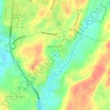
Name: Spackenkill topographic map, elevation, terrain.
Average elevation: 171 ft
Minimum elevation: 82 ft
Maximum elevation: 262 ft
Dutchess County trails, hiking, mountain biking, running and outdoor activities
Make a donation
Gear up for your next adventure:
As an Amazon Associate, this site earns from qualifying purchases at no extra cost to you.
Other topographic maps
Click on a map to view its topography, its elevation and its terrain.
Shenandoah
United States > New York > Dutchess County > Town of East Fishkill
Average elevation: 502 ft
Annandale-on-Hudson
United States > New York > Dutchess County > Town of Red Hook
Average elevation: 141 ft
Timothy Heights
United States > New York > Dutchess County > Town of Pleasant Valley
Average elevation: 285 ft
Make a donation
Gear up for your next adventure:
As an Amazon Associate, this site earns from qualifying purchases at no extra cost to you.
Make a donation
Gear up for your next adventure:
As an Amazon Associate, this site earns from qualifying purchases at no extra cost to you.
Drayton Grant Park at Burger Hill
United States > New York > Dutchess County > Town of Rhinebeck
Average elevation: 335 ft
Stissing Mountain Multiple Use Area
United States > New York > Dutchess County > Town of Pine Plains
Average elevation: 712 ft
Make a donation
Gear up for your next adventure:
As an Amazon Associate, this site earns from qualifying purchases at no extra cost to you.
Alamar Unit
United States > New York > Dutchess County > Town of East Fishkill
Average elevation: 912 ft
Pecksville
United States > New York > Dutchess County > Town of East Fishkill
Average elevation: 899 ft
Mt. Beacon Fire Observation Tower
United States > New York > Dutchess County
Average elevation: 965 ft
Make a donation
Gear up for your next adventure:
As an Amazon Associate, this site earns from qualifying purchases at no extra cost to you.
Stormville
United States > New York > Dutchess County > Town of East Fishkill
Average elevation: 367 ft
Make a donation
Gear up for your next adventure:
As an Amazon Associate, this site earns from qualifying purchases at no extra cost to you.
Netherwood
United States > New York > Dutchess County > Town of Pleasant Valley
Average elevation: 361 ft
Make a donation
Gear up for your next adventure:
As an Amazon Associate, this site earns from qualifying purchases at no extra cost to you.
United States of America Property
United States > New York > Dutchess County > Village of Pawling
Average elevation: 823 ft
Make a donation
Gear up for your next adventure:
As an Amazon Associate, this site earns from qualifying purchases at no extra cost to you.
Make a donation
Gear up for your next adventure:
As an Amazon Associate, this site earns from qualifying purchases at no extra cost to you.