Geolocate

Bhukum topographic map

Click on the map to display elevation.

About this map

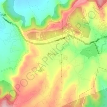
Name: Bhukum topographic map, elevation, terrain.

Location: Bhukum, Mulshi, Pune District, Maharashtra, 412115, India (18.47454 73.70140 18.51454 73.74140)

Average elevation: 2,316 ft

Minimum elevation: 1,952 ft

Maximum elevation: 2,697 ft

Other topographic maps

Click on a map to view its topography, its elevation and its terrain.

Aamby Valley

India > Maharashtra > Mulshi

Average elevation: 2,329 ft

Manas Lake

India > Maharashtra > Mulshi > Bhukum

Average elevation: 2,306 ft

Mulshi Lake

India > Maharashtra > Mulshi > Chachivali

Average elevation: 2,329 ft

Katarkhadak

India > Maharashtra > Mulshi

Average elevation: 2,657 ft

Mula

India > Maharashtra > Mulshi

Average elevation: 2,159 ft

Kasarsai

India > Maharashtra > Mulshi > Nere

Average elevation: 1,985 ft

Gear up for your next adventure:

🪑Ultralight Camp Chairs - Portable seating for resting after a long day of mapping
🧢Outdoor Hiking Hat - Sun protection hat for outdoor explorers
🚗GPS Dash Cams - Record your scenic drives through mountain passes and canyons
Solar GPS Watches - Advanced multisport watches with built-in topographic maps
🎒Waterproof Dry Bags - Keep your electronics and maps dry inside your pack

As an Amazon Associate, this site earns from qualifying purchases at no extra cost to you.