
Bouhmama topographic map
Interactive map
Click on the map to display elevation.
About this map
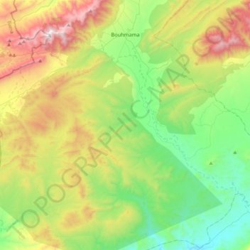
Name: Bouhmama topographic map, elevation, terrain.
Location: Bouhmama, Daïra Bouhmama, Khenchela, 40007, Algérie (35.06521 6.61001 35.35641 6.97390)
Average elevation: 4,226 ft
Minimum elevation: 2,477 ft
Maximum elevation: 7,582 ft
Other topographic maps
Click on a map to view its topography, its elevation and its terrain.
M'Sara
Algérie > Khenchela > Daïra Bouhmama
M'Sara, Daïra Bouhmama, Khenchela, Algérie
Average elevation: 4,377 ft
Yabous
Algérie > Khenchela > Daïra Bouhmama > Yabous
Yabous, Daïra Bouhmama, Khenchela, Algérie
Average elevation: 4,478 ft
Aures Mountains
Algérie > Khenchela > Daïra Bouhmama > Bouhmama
Aures Mountains, Bouhmama, Daïra Bouhmama, Khenchela, Algérie
Average elevation: 6,444 ft