
M'Sara topographic map
Interactive map
Click on the map to display elevation.
About this map
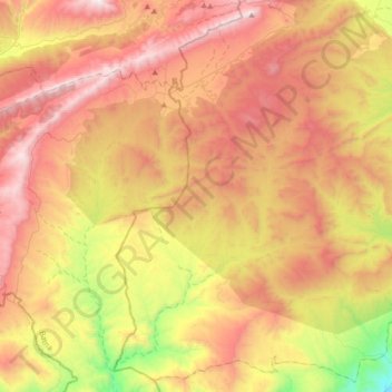
Name: M'Sara topographic map, elevation, terrain.
Location: M'Sara, Daïra Bouhmama, Khenchela, Algérie (35.01457 6.49730 35.29154 6.85332)
Average elevation: 4,377 ft
Minimum elevation: 1,827 ft
Maximum elevation: 6,680 ft
Other topographic maps
Click on a map to view its topography, its elevation and its terrain.
Bouhmama
Algérie > Khenchela > Daïra Bouhmama
Bouhmama, Daïra Bouhmama, Khenchela, 40007, Algérie
Average elevation: 4,226 ft
Yabous
Algérie > Khenchela > Daïra Bouhmama > Yabous
Yabous, Daïra Bouhmama, Khenchela, Algérie
Average elevation: 4,478 ft
Aures Mountains
Algérie > Khenchela > Daïra Bouhmama > Bouhmama
Aures Mountains, Bouhmama, Daïra Bouhmama, Khenchela, Algérie
Average elevation: 6,444 ft