Geolocate

Winlaw topographic map

Click on the map to display elevation.

About this map

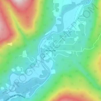
Name: Winlaw topographic map, elevation, terrain.

Location: Winlaw, Area H (The Slocan Valley), Regional District of Central Kootenay, British Columbia, V0G 2J0, Canada (49.59082 -117.58343 49.63082 -117.54343)

Average elevation: 2,277 ft

Minimum elevation: 1,647 ft

Maximum elevation: 4,081 ft

Other topographic maps

Click on a map to view its topography, its elevation and its terrain.

Gear up for your next adventure:

🌧️Backpack Rain Cover - Keep gear dry in wet weather
GPS Sports Watch - GPS watch for running, hiking and training
🧦Hiking Socks - Comfortable socks to prevent blisters on long hikes
🪶Thermal Camp Blanket - Extra warmth for cold nights
🧯Portable Fire Pit - Compact fire pit for camping spots

As an Amazon Associate, this site earns from qualifying purchases at no extra cost to you.