Geolocate

Boston topographic map

Click on the map to display elevation.

About this map

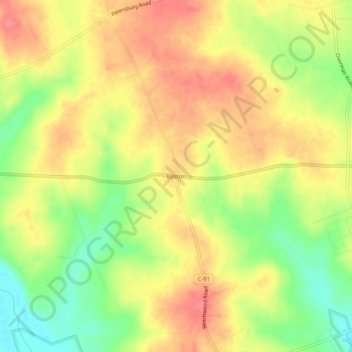
Name: Boston topographic map, elevation, terrain.

Location: Boston, Highland County, Ohio, United States (39.19534 -83.53103 39.23534 -83.49103)

Average elevation: 1,004 ft

Minimum elevation: 873 ft

Maximum elevation: 1,102 ft

Highland County trails, hiking, mountain biking, running and outdoor activities

Other topographic maps

Click on a map to view its topography, its elevation and its terrain.

Rocky Fork Lake

United States > Ohio > Highland County

Average elevation: 955 ft

Lynchburg

United States > Ohio > Highland County

Average elevation: 1,017 ft

Hillsboro

United States > Ohio > Highland County

Average elevation: 1,027 ft

Highland

United States > Ohio > Highland County

Average elevation: 1,070 ft

Paint Creek Lake

United States > Ohio > Highland County

Average elevation: 909 ft

Mowrystown

United States > Ohio > Highland County

Average elevation: 981 ft

Gear up for your next adventure:

🛠️Outdoor Gear Repair Kit - Essential tools to fix gear on the trail
🧭Outdoor Navigation Book - Learn advanced navigation skills
🛡️Insect Repellent - Protection against bugs during outdoor activities
🎒Trail Energy Bars - High‑calorie bars for hiking energy
🌧️Backpack Rain Cover - Keep gear dry in wet weather

As an Amazon Associate, this site earns from qualifying purchases at no extra cost to you.