Geolocate

Bonaire topographic map

Click on the map to display elevation.

About this map
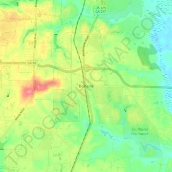
Name: Bonaire topographic map, elevation, terrain.

Location: Bonaire, Houston County, Georgia, 31005, United States (32.50384 -83.63603 32.58384 -83.55603)

Average elevation: 328 ft

Minimum elevation: 213 ft

Maximum elevation: 495 ft

Houston County trails, hiking, mountain biking, running and outdoor activities

Other topographic maps

Click on a map to view its topography, its elevation and its terrain.
Warner Robins

United States > Georgia > Houston County

Average elevation: 331 ft

Perry

United States > Georgia > Houston County

Average elevation: 364 ft

Warner Robins

United States > Georgia > Houston County

Average elevation: 331 ft

Lake Joy

United States > Georgia > Houston County

Average elevation: 344 ft

Perry

United States > Georgia > Houston County

Average elevation: 364 ft

Gear up for your next adventure:

🧦Merino Wool Socks - Moisture-wicking, blister-preventing socks for long treks
🦟Ultrasonic Repellers - Create a bug-free zone at your camp or rest stop
📷Action Camera - Capture your outdoor adventures in HD
🏥Hiking First Aid Kits - Comprehensive medical kits for remote trail injuries
🪶Wildlife Field Guides - Learn animal tracking and species ID

As an Amazon Associate, this site earns from qualifying purchases at no extra cost to you.