Geolocate

Wayne Lakes topographic map

Click on the map to display elevation.

About this map

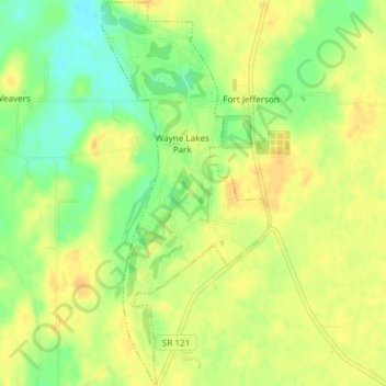
Name: Wayne Lakes topographic map, elevation, terrain.

Location: Wayne Lakes, Darke County, Ohio, United States (40.00511 -84.66975 40.03369 -84.65348)

Average elevation: 1,073 ft

Minimum elevation: 1,014 ft

Maximum elevation: 1,109 ft

Darke County trails, hiking, mountain biking, running and outdoor activities

Other topographic maps

Click on a map to view its topography, its elevation and its terrain.

Union Corners

United States > Ohio > Darke County

Average elevation: 1,010 ft

Webster

United States > Ohio > Darke County

Average elevation: 991 ft

Horatio

United States > Ohio > Darke County

Average elevation: 1,010 ft

Abbottsville

United States > Ohio > Darke County

Average elevation: 1,050 ft

Hill Grove

United States > Ohio > Darke County

Average elevation: 1,073 ft

Delisle

United States > Ohio > Darke County

Average elevation: 1,053 ft

Gear up for your next adventure:

🛠️Outdoor Gear Repair Kit - Essential tools to fix gear on the trail
🚗GPS Dash Cams - Record your scenic drives through mountain passes and canyons
🌡️Handheld Weather Meters - Measure wind, temp, and pressure for safe mountain travel
🥩Freeze-Dried Meals - Nutritious and lightweight food for remote expeditions
🪶Survival Guide Book - Expert advice for emergency preparedness

As an Amazon Associate, this site earns from qualifying purchases at no extra cost to you.