
Clearview topographic map
Click on the map to display elevation.
About this map
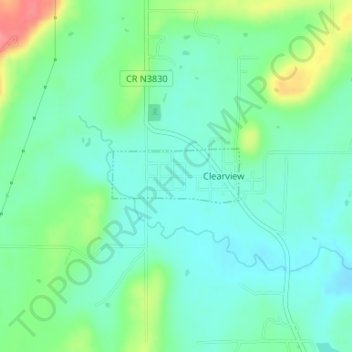
Name: Clearview topographic map, elevation, terrain.
Location: Clearview, Okfuskee County, Oklahoma, United States (35.39495 -96.19689 35.39911 -96.18490)
Average elevation: 823 ft
Minimum elevation: 751 ft
Maximum elevation: 997 ft
Okfuskee County trails, hiking, mountain biking, running and outdoor activities
Other topographic maps
Click on a map to view its topography, its elevation and its terrain.