Geolocate

Brigham topographic map

Click on the map to display elevation.

About this map

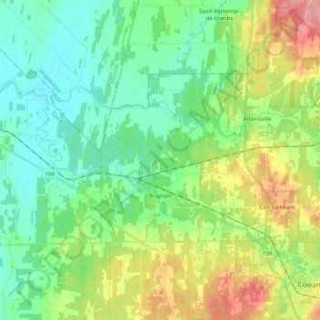
Name: Brigham topographic map, elevation, terrain.

Location: Brigham, Brome-Missisquoi, Estrie, Quebec, J2K 4V6, Canada (45.22388 -72.88277 45.29980 -72.68404)

Average elevation: 315 ft

Minimum elevation: 210 ft

Maximum elevation: 538 ft

Other topographic maps

Click on a map to view its topography, its elevation and its terrain.

Knowlton

Canada > Quebec > Brome-Missisquoi > Lac-Brome

Average elevation: 768 ft

Mont Brome

Canada > Quebec > Brome-Missisquoi > Bromont

Average elevation: 1,086 ft

West Brome

Canada > Quebec > Brome-Missisquoi > Lac-Brome

Average elevation: 531 ft

Gear up for your next adventure:

📶Vehicle Signal Boosters - Improve reception in rural areas while driving to trailheads
🌐World Map Poster - Decorative world maps with topographic info
🔪Outdoor Multitools - Essential survival tools for gear repair and field use
🗻Climbing Gear Basics - Essential gear for beginner climbers
🩳Quick‑Dry Hiking Shorts - Comfortable and quick‑dry shorts for summer hiking

As an Amazon Associate, this site earns from qualifying purchases at no extra cost to you.