
Wells topographic map
Click on the map to display elevation.
About this map
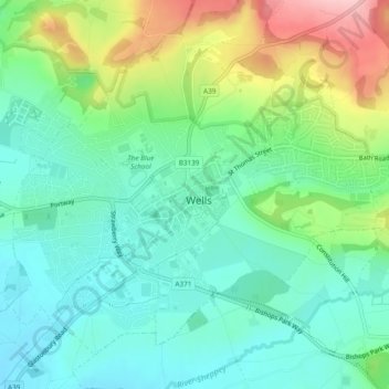
Name: Wells topographic map, elevation, terrain.
Location: Wells, Somerset, England, United Kingdom (51.19764 -2.66890 51.22207 -2.62136)
Average elevation: 226 ft
Minimum elevation: 52 ft
Maximum elevation: 610 ft
Other topographic maps
Click on a map to view its topography, its elevation and its terrain.
Chard
United Kingdom > England > Somerset
Chard is a town and a civil parish in the English county of Somerset. It lies on the A30 road near the Devon and Dorset borders, 15 miles (24 km) south west of Yeovil. The parish has a population of approximately 14,000 and, at an elevation of 121 metres (397 ft), Chard is the southernmost and one of the…
Average elevation: 443 ft
Horner Water
United Kingdom > England > Somerset > Somerset West and Taunton > Luccombe
Average elevation: 814 ft
Bossington
United Kingdom > England > Somerset > Somerset West and Taunton > Bossington
Average elevation: 226 ft
Halse Combe
United Kingdom > England > Somerset > Somerset West and Taunton > Allerford > Horner
Average elevation: 440 ft