Geolocate

Ashington topographic map

Click on the map to display elevation.

About this map

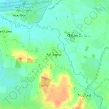
Name: Ashington topographic map, elevation, terrain.

Location: Ashington, Somerset, England, BA22 8ED, United Kingdom (50.97008 -2.64615 51.01008 -2.60615)

Average elevation: 82 ft

Minimum elevation: 43 ft

Maximum elevation: 167 ft

Other topographic maps

Click on a map to view its topography, its elevation and its terrain.

Ilminster

United Kingdom > England > Somerset

Average elevation: 184 ft

Buckland Dinham

United Kingdom > England > Somerset

Average elevation: 338 ft

Wellington

United Kingdom > England > Somerset

Average elevation: 246 ft

Tintinhull

United Kingdom > England > Somerset

Average elevation: 89 ft

Ashcott

United Kingdom > England > Somerset

Average elevation: 72 ft

Pawlett

United Kingdom > England > Somerset > Pawlett

Average elevation: 20 ft

Wells

United Kingdom > England > Somerset

Average elevation: 226 ft

Bird Pond

United Kingdom > England > Somerset > Brompton Regis > Hartford

Average elevation: 830 ft

Ston Easton

United Kingdom > England > Somerset

Average elevation: 499 ft

Langport

United Kingdom > England > Somerset

Average elevation: 59 ft

Ashill

United Kingdom > England > Somerset

Average elevation: 177 ft

Woolavington

United Kingdom > England > Somerset

Average elevation: 56 ft

West Bradley

United Kingdom > England > Somerset

Average elevation: 164 ft

Buckland St Mary

United Kingdom > England > Somerset

Average elevation: 636 ft

North Barrow

United Kingdom > England > Somerset

Average elevation: 121 ft

Frome

United Kingdom > England > Somerset

Average elevation: 295 ft

Holcombe

United Kingdom > England > Somerset > Mendip

Average elevation: 545 ft

Wedmore

United Kingdom > England > Somerset

Average elevation: 49 ft

Cheddar

United Kingdom > England > Somerset > Sedgemoor

Average elevation: 358 ft

Norton St Philip

United Kingdom > England > Somerset > Mendip

Average elevation: 295 ft

Cannington

United Kingdom > England > Somerset > Sedgemoor

Average elevation: 95 ft

Wembdon

United Kingdom > England > Somerset > Sedgemoor

Average elevation: 30 ft

Axbridge

United Kingdom > England > Somerset > Sedgemoor

Average elevation: 220 ft

Street

United Kingdom > England > Somerset > Mendip

Average elevation: 75 ft

Gear up for your next adventure:

🌄Hiking Binoculars - Compact binoculars for scenic views and trail spotting
🪶Trail Camera - Capture wildlife on your hikes
🔥Fast-Boil Camping Stoves - Efficient cooking systems for quick trail meals
🧭Pro Hiking Compasses - High-accuracy liquid-filled compasses for topographic orientation
🛏️Cold Weather Sleeping Bag - Warm sleeping bag for cold conditions

As an Amazon Associate, this site earns from qualifying purchases at no extra cost to you.