
Make a donation
Gear up for your next adventure:
As an Amazon Associate, this site earns from qualifying purchases at no extra cost to you.
Bad Dürrheim topographic map
Click on the map to display elevation.
Make a donation
Gear up for your next adventure:
As an Amazon Associate, this site earns from qualifying purchases at no extra cost to you.
About this map
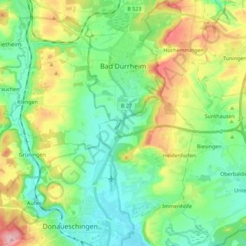
Name: Bad Dürrheim topographic map, elevation, terrain.
Average elevation: 2,365 ft
Minimum elevation: 2,201 ft
Maximum elevation: 2,710 ft
Make a donation
Gear up for your next adventure:
As an Amazon Associate, this site earns from qualifying purchases at no extra cost to you.
Other topographic maps
Click on a map to view its topography, its elevation and its terrain.
Escheck
Germany > Baden-Württemberg > Schwarzwald-Baar-Kreis > Furtwangen im Schwarzwald
Average elevation: 3,317 ft
Triberg
Germany > Baden-Württemberg > Schwarzwald-Baar-Kreis > Bräunlingen
Average elevation: 2,382 ft
Gremmelsbach
Germany > Baden-Württemberg > Schwarzwald-Baar-Kreis > Triberg im Schwarzwald > Gremmelsbach
Average elevation: 2,546 ft