Geolocate

Loppa topographic map

Click on the map to display elevation.

👉 Easily get elevation data in JSON, GeoTIFF and KML formats using Elevation API
Thank you for supporting this site ❤️
Make a donation

About this map

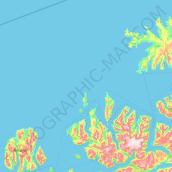
Name: Loppa topographic map, elevation, terrain.

Location: Loppa, Troms og Finnmark, Norway (70.03870 20.47973 70.79002 22.60369)

Average elevation: 295 ft

Minimum elevation: -16 ft

Maximum elevation: 3,940 ft

Other topographic maps

Click on a map to view its topography, its elevation and its terrain.

Alta

Norway > Troms og Finnmark

Average elevation: 112 ft

Skjolden

Norway > Troms og Finnmark > Sørvær

Average elevation: 410 ft

Bjørnevatn

Norway > Troms og Finnmark

Average elevation: 269 ft

Dyrstad

Norway > Troms og Finnmark

Average elevation: 203 ft

Máze - Masi

Norway > Troms og Finnmark

Average elevation: 1,165 ft

Setermoen

Norway > Troms og Finnmark > Setermoen

Average elevation: 407 ft

Roavvegieddi

Norway > Troms og Finnmark

Average elevation: 512 ft

Laksvatn

Norway > Troms og Finnmark

Average elevation: 699 ft

Moen

Norway > Troms og Finnmark

Average elevation: 328 ft

Gear up for your next adventure:

🪶Camping Sleeping Pad - Comfortable sleeping pad for backpacking
🥾Men's Hiking Boots - Durable, waterproof footwear for rugged terrain and steep inclines
🪶Wildlife Field Guides - Learn animal tracking and species ID
👖Convertible Hiking Pants - Versatile zip-off pants for changing altitudes and temperatures
🎒Trail Energy Bars - High‑calorie bars for hiking energy

As an Amazon Associate, this site earns from qualifying purchases at no extra cost to you.