Geolocate

Solsona topographic map

Click on the map to display elevation.

About this map

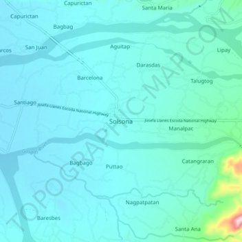
Name: Solsona topographic map, elevation, terrain.

Location: Solsona, Ilocos Norte, Ilocos Region, 2910, Philippines (18.05536 120.73321 18.13536 120.81321)

Average elevation: 207 ft

Minimum elevation: 98 ft

Maximum elevation: 1,250 ft

Other topographic maps

Click on a map to view its topography, its elevation and its terrain.

Brgy. 58- Casili

Philippines > Ilocos Norte

Average elevation: 33 ft

Paoay Lake

Philippines > Ilocos Norte > Suba

Average elevation: 85 ft

Pagudpud

Philippines > Ilocos Norte

The town's topography includes mountains, hills, valleys and flat coastal land.

Average elevation: 233 ft

Laoag

Philippines > Ilocos Norte

Average elevation: 135 ft

Gear up for your next adventure:

🔋Solar Power Banks - Keep your GPS and phone charged in remote wilderness areas
🔥Fast-Boil Camping Stoves - Efficient cooking systems for quick trail meals
🪶Camp Gear Gift Set - Perfect gift bundle for outdoor fans
🛰️Handheld GPS Units - Professional satellite navigators for precise backcountry mapping
📚Navigation Handbooks - Master the art of reading topographic maps and using a compass

As an Amazon Associate, this site earns from qualifying purchases at no extra cost to you.