
Rialto topographic map
Click on the map to display elevation.
Rialto
The particularly arid climate during the summer prevents tropospheric clouds from forming, meaning temperatures rise to what is considered Class Orange by NOAA. Rialto gets an average of 16 inches (410 mm) of rain, and maybe hail most of this rainfall precipitates in winter. During winter, Rialto's northernmost neighborhood gets snow, heavily at times as a result of its elevation of about 3,000 feet (910 m) above sea level. However, most of the city is out of snowfall's path.
About this map
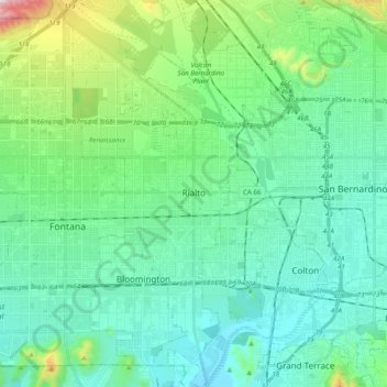
Name: Rialto topographic map, elevation, terrain.
Location: Rialto, San Bernardino County, California, United States (34.02459 -117.43679 34.18715 -117.34104)
Average elevation: 1,283 ft
Minimum elevation: 833 ft
Maximum elevation: 3,100 ft
San Bernardino County trails, hiking, mountain biking, running and outdoor activities
Other topographic maps
Click on a map to view its topography, its elevation and its terrain.
Cajon Pass
United States > California > San Bernardino County
Cajon Pass (/kəˈhoʊn/; Spanish: Puerto del Cajón or Paso del Cajón) is a mountain pass between the San Bernardino Mountains to the east and the San Gabriel Mountains to the west in Southern California. Created by the movements of the San Andreas Fault, it has an elevation of 3,777 ft (1,151 m). Located in…
Average elevation: 3,835 ft
Running Springs
United States > California > San Bernardino County
Running Springs is a mountain community in the San Bernardino Mountains. It is an inholding in the San Bernardino National Forest. Situated at the junction of State Route 18 and State Route 330, it is a major gateway to the mountain communities of Lake Arrowhead, Arrowbear, Green Valley Lake, and Big Bear and…
Average elevation: 5,489 ft
Cedar Glen
United States > California > San Bernardino County > Lake Arrowhead
Average elevation: 5,381 ft
Meadowbrook Woods
United States > California > San Bernardino County > Lake Arrowhead
Average elevation: 5,118 ft
Running Springs
United States > California > San Bernardino County > Running Springs
Running Springs is a mountain community in the San Bernardino Mountains. It is an inholding in the San Bernardino National Forest. Situated at the junction of State Route 18 and State Route 330, it is a major gateway to the mountain communities of Lake Arrowhead, Arrowbear, Green Valley Lake, and Big Bear and…
Average elevation: 5,433 ft
Devil Canyon
United States > California > San Bernardino County > San Bernardino
Average elevation: 2,060 ft
East Colton Heights
United States > California > San Bernardino County > Colton
Average elevation: 1,070 ft
San Gorgonio Mountain
United States > California > San Bernardino County
Since it is the highest point in a region which is separated from higher peaks (e.g. in the Sierra Nevada) by relatively low terrain, San Gorgonio Mountain is one of the most topographically prominent peaks in the United States. It is ranked 7th among peaks in the 48 contiguous states and 18th overall.
Average elevation: 10,348 ft
Los Serranos
United States > California > San Bernardino County > Chino Hills
Average elevation: 696 ft
Arrowbear Lake
United States > California > San Bernardino County > Running Springs
Arrowbear Lake is an unincorporated community in San Bernardino County, California, United States. Its altitude is 6,086 feet (1,855 m) in the San Bernardino Mountains. It is located east of Running Springs along Highway 18 in the San Bernardino National Forest, a mountain community with a population of 736 in…
Average elevation: 6,325 ft
Ruben S Ayala Park
United States > California > San Bernardino County > Chino
Average elevation: 656 ft
Strawberry Peak
United States > California > San Bernardino County > Twin Peaks
Average elevation: 5,318 ft
Moonridge
United States > California > San Bernardino County > Big Bear Lake
Average elevation: 7,254 ft
Cucamonga Peak
United States > California > San Bernardino County
Cucamonga Peak is one of the highest peaks of the San Gabriel Mountains in San Bernardino County, California, with a summit elevation of 8,862 feet (2,701 m). It is within the Cucamonga Wilderness of the San Bernardino National Forest.
Average elevation: 7,349 ft
Fort Irwin
United States > California > San Bernardino County
Fort Irwin National Training Center (Fort Irwin NTC) is a major training area for the United States military in the Mojave Desert in northern San Bernardino County, California. Fort Irwin is at an average elevation of 2,454 feet (748 m). It is located 37 miles (60 km) northeast of Barstow, in the Calico…
Average elevation: 2,539 ft
John Tooker Civic Park
United States > California > San Bernardino County > Yucaipa
Average elevation: 2,487 ft
Ruben S Ayala Park
United States > California > San Bernardino County > Chino
Average elevation: 656 ft
Lake Gregory
United States > California > San Bernardino County > Crestline
Average elevation: 4,764 ft
Running Springs
United States > California > San Bernardino County > Running Springs
Running Springs is a mountain community in the San Bernardino Mountains. It is an inholding in the San Bernardino National Forest. Situated at the junction of State Route 18 and State Route 330, it is a major gateway to the mountain communities of Lake Arrowhead, Arrowbear, Green Valley Lake, and Big Bear and…
Average elevation: 5,433 ft
May Van Canyon Artesian Well
United States > California > San Bernardino County
Average elevation: 7,779 ft
Moonridge
United States > California > San Bernardino County > Big Bear Lake
Average elevation: 7,254 ft
High Country
United States > California > San Bernardino County > Hesperia
Average elevation: 3,622 ft
Running Springs
United States > California > San Bernardino County
Running Springs is a mountain community in the San Bernardino Mountains. It is an inholding in the San Bernardino National Forest. Situated at the junction of State Route 18 and State Route 330, it is a major gateway to the mountain communities of Lake Arrowhead, Arrowbear, Green Valley Lake, and Big Bear and…
Average elevation: 5,489 ft
Los Serranos
United States > California > San Bernardino County > Chino Hills
Average elevation: 696 ft
Moonridge
United States > California > San Bernardino County > Big Bear Lake
Average elevation: 7,254 ft
Devils Canyon Dike Number 1 17-002 Dam
United States > California > San Bernardino County > San Bernardino
Average elevation: 1,703 ft
Desert Knolls Manor
United States > California > San Bernardino County > Apple Valley
Average elevation: 3,045 ft
Devil Canyon
United States > California > San Bernardino County > San Bernardino
Average elevation: 2,060 ft
Greenbelt Park
United States > California > San Bernardino County > Upland
Average elevation: 1,480 ft
targets?
United States > California > San Bernardino County > Lucerne Valley
Average elevation: 4,236 ft