
Devore topographic map
Click on the map to display elevation.
About this map
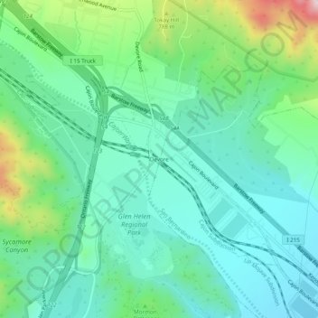
Name: Devore topographic map, elevation, terrain.
Location: Devore, San Bernardino County, California, United States (34.19640 -117.42144 34.23640 -117.38144)
Average elevation: 2,172 ft
Minimum elevation: 1,791 ft
Maximum elevation: 3,310 ft
San Bernardino County trails, hiking, mountain biking, running and outdoor activities
Other topographic maps
Click on a map to view its topography, its elevation and its terrain.
Apple Valley
United States > California > San Bernardino County
The elevation of Apple Valley is approximately 2,900 feet (880 m) above sea level.
Average elevation: 3,205 ft
Upland
United States > California > San Bernardino County
Upland is a city in San Bernardino County, California, United States. The municipality is located at an elevation of 1,242 feet (379 m). As of the 2010 census, the city had a population of 73,732, up from 68,393 at the 2000 census. It was incorporated on May 15, 1906, after previously being named North…
Average elevation: 1,499 ft
Grand Terrace
United States > California > San Bernardino County
This 3.6-square-mile (9.3 km2) community has an average elevation of 1,065 feet (325 m). Its motto, inscribed on the city flag, is "The Blue Mountain City" (its official slogan is "A city set upon a mountain cannot be hidden"), and refers to the Blue Lupine flower that used to grow on Blue Mountain in the…
Average elevation: 1,125 ft
San Bernardino
United States > California > San Bernardino County
San Bernardino features a hot-summer Mediterranean climate (Csa in the Köppen climate classification) with mild winters and hot, dry summers. Relative to other areas in Southern California, winters are colder, with frost and with chilly to cold morning temperatures common. The particularly arid climate during…
Average elevation: 2,172 ft
Victorville
United States > California > San Bernardino County
Victorville is bordered by Apple Valley on the east, Hesperia on the south, and Adelanto on the west. The Mojave River flows sporadically through Victorville. The elevation at City Hall is approximately 2,950 feet (900 m) above sea level.
Average elevation: 3,018 ft
Piñon Hills
United States > California > San Bernardino County
Piñon Hills (from piñón, Spanish for 'pine nut') is a census-designated place in San Bernardino County, California, near the Los Angeles County line. It is located along Pearblossom Highway, 28 miles east of Palmdale, and 15 miles west of the Cajon Pass where Pearblossom Highway meets Interstate 15. The…
Average elevation: 3,973 ft
Hesperia
United States > California > San Bernardino County
Hesperia is a city in San Bernardino County, California, United States. It is located 35 miles (56 km) north of downtown San Bernardino in Victor Valley and surrounded by the Mojave Desert. Because of its relatively high elevation and the unique and moderate weather patterns of the region, Hesperia is part of…
Average elevation: 3,369 ft
San Bernardino National Forest
United States > California > San Bernardino County
The San Bernardino National Forest is a United States National Forest in Southern California encompassing 823,816 acres (3,333.87 km2) of which 677,982 acres (2,743.70 km2) are federal. The forest is made up of two main divisions, the eastern portion of the San Gabriel Mountains and the San Bernardino…
Average elevation: 3,310 ft
Rialto
United States > California > San Bernardino County
The particularly arid climate during the summer prevents tropospheric clouds from forming, meaning temperatures rise to what is considered Class Orange by NOAA. Rialto gets an average of 16 inches (410 mm) of rain, and maybe hail most of this rainfall precipitates in winter. During winter, Rialto's…
Average elevation: 1,283 ft
Chino Hills
United States > California > San Bernardino County
Due to its topography of rolling hills, Chino Hills was primarily rural prior to the mid-1970s; most land was utilized for equestrian purposes and for dairies, except for the multi-use purposes of the State of California, promoting jobs for the community through day labor from the Chino Institute for Men on…
Average elevation: 840 ft
Big Bear City
United States > California > San Bernardino County > Big Bear City
It is estimated that the Serrano natives first settled in Big Bear between 1,500 and 2,000 years ago. The Serranos had both winter and summer settlements throughout the area. While their winter village was located in Lucerne Valley, they relocated to villages in the San Bernardino mountains during summer, as…
Average elevation: 7,264 ft
Muscoy
United States > California > San Bernardino County > Rialto
Muscoy is located at 34°9′22″N 117°20′48″W / 34.15611°N 117.34667°W / 34.15611; -117.34667 (34.156009, -117.346552). Elevation ranges from 1240' in the south to 1600' in the north.
Average elevation: 1,421 ft
Fontana
United States > California > San Bernardino County
Most of the city of Fontana, like its eastern neighbors Rialto and San Bernardino, is built atop a geologically young, gently southward-sloping alluvial fan from nearby Lytle Creek, deposited mainly during the Holocene and late-Pleistocene epochs. There are also sedimentary deposits of similar age from…
Average elevation: 1,358 ft
Etiwanda
United States > California > San Bernardino County > Rancho Cucamonga
Average elevation: 1,775 ft
Running Springs
United States > California > San Bernardino County > Running Springs
Running Springs is a mountain community in the San Bernardino Mountains. It is an inholding in the San Bernardino National Forest. Situated at the junction of State Route 18 and State Route 330, it is a major gateway to the mountain communities of Lake Arrowhead, Arrowbear, Green Valley Lake, and Big Bear and…
Average elevation: 5,433 ft
Phelan
United States > California > San Bernardino County
Southwestern areas of Phelan are in the foothills of the San Gabriel Mountains, reaching elevations of more than 4,900 feet above sea level. The California Aqueduct runs through the northern half of the town, eleven miles (18 km) from State Route 18 and ten miles (16 km) from Phelan Road. Covering more than 60…
Average elevation: 3,875 ft
Lucerne Valley
United States > California > San Bernardino County > Lucerne Valley
Average elevation: 3,763 ft
Big Bear Lake
United States > California > San Bernardino County
Since 1970, Big Bear Lake has held its annual Oktoberfest. The Big Bear Lake Oktoberfest also sports the highest beer garden, by elevation, in the United States. Big Bear Lake was incorporated as a city on November 28, 1980.
Average elevation: 6,995 ft
Castle Mountains National Monument
United States > California > San Bernardino County
The national monument protects a section of the Castle Mountains, a range located in San Bernardino County and Clark County, Nevada. The range lies south and east of the New York Mountains, southwest of Searchlight and west of Cal-Nev-Ari, Nevada. The range lies at the northeastern end of Lanfair Valley and…
Average elevation: 4,049 ft
Ruben S Ayala Park
United States > California > San Bernardino County > Chino
Average elevation: 656 ft
Running Springs
United States > California > San Bernardino County > Running Springs
Running Springs is a mountain community in the San Bernardino Mountains. It is an inholding in the San Bernardino National Forest. Situated at the junction of State Route 18 and State Route 330, it is a major gateway to the mountain communities of Lake Arrowhead, Arrowbear, Green Valley Lake, and Big Bear and…
Average elevation: 5,436 ft
Wrightwood
United States > California > San Bernardino County > Wrightwood
Wrightwood is a census-designated place in San Bernardino County, California. It sits at an elevation of 6,000 feet (1,800 m). The population was 4,525 at the 2010 census, up from the population of 3,837 at the 2000 census. Wrightwood is located 77 miles (124 km) northeast of Los Angeles. Wrightwood is on the…
Average elevation: 6,378 ft
Twentynine Palms
United States > California > San Bernardino County
According to the United States Census Bureau, the city has a total area of 59.1 square miles (153 km2), all land. The city is at an elevation of 1,988 feet (606 m). The Marine Corps Air Ground Combat Center Twentynine Palms is located there.
Average elevation: 2,267 ft
Adelanto
United States > California > San Bernardino County
The average elevation of the city is 3,400 ft (1,036 m).
Average elevation: 2,897 ft
Yucca Valley
United States > California > San Bernardino County
Yucca Valley lies in the middle of the Morongo Basin at a base elevation of 3,300 feet. Joshua Tree National Park is adjacent to its southern border.
Average elevation: 3,629 ft
Joshua Tree
United States > California > San Bernardino County > Joshua Tree
Average elevation: 3,215 ft
Lake Arrowhead
United States > California > San Bernardino County > Blue Jay
Average elevation: 5,128 ft
Cucamonga Wilderness
United States > California > San Bernardino County > Mount Baldy
Elevations range from about 5,000 to 9,000 feet (1,500 to 2,700 m).
Average elevation: 6,631 ft
Helendale
United States > California > San Bernardino County
Helendale is located in a generally flat area in the Mojave Desert, between Victorville and Barstow. It is located 100 miles (160 km) northeast of Los Angeles and 180 miles (290 km) southwest of Las Vegas at an elevation of 2,464 feet (751 m).
Average elevation: 2,713 ft
Oro Grande
United States > California > San Bernardino County
Oro Grande (Spanish for "Large Gold") is an unincorporated community in the Mojave Desert of San Bernardino County, California, United States. It lies on the city boundary of Victorville and Adelanto. It is at 3,000 feet (910 m) elevation in Victor Valley north of the San Bernardino mountain range. It is…
Average elevation: 2,959 ft
Baker
United States > California > San Bernardino County > Baker
Baker is located in the Mojave Desert at the junction of Interstate 15 and SR 127 (Death Valley Road). Its elevation is approximately 930 feet (283.5 m) above sea level, which is much lower than either Barstow or Las Vegas, due to its location at the southern end of the Death Valley geological depression. The…
Average elevation: 984 ft
Morongo Valley
United States > California > San Bernardino County > Morongo Valley
Average elevation: 3,438 ft
Hesperia
United States > California > San Bernardino County
Hesperia is a city in San Bernardino County, California, United States. It is located 35 miles (56 km) north of downtown San Bernardino in Victor Valley and surrounded by the Mojave Desert. Because of its relatively high elevation and the unique and moderate weather patterns of the region, Hesperia is part of…
Average elevation: 3,369 ft
Fontana
United States > California > San Bernardino County
Most of the city of Fontana, like its eastern neighbors Rialto and San Bernardino, is built atop a geologically young, gently southward-sloping alluvial fan from nearby Lytle Creek, deposited mainly during the Holocene and late-Pleistocene epochs. There are also sedimentary deposits of similar age from…
Average elevation: 1,358 ft
Victorville
United States > California > San Bernardino County
Victorville is bordered by Apple Valley on the east, Hesperia on the south, and Adelanto on the west. The Mojave River flows sporadically through Victorville. The elevation at City Hall is approximately 2,950 feet (900 m) above sea level.
Average elevation: 3,018 ft
Grand Terrace
United States > California > San Bernardino County
This 3.6-square-mile (9.3 km2) community has an average elevation of 1,065 feet (325 m). Its motto, inscribed on the city flag, is "The Blue Mountain City" (its official slogan is "A city set upon a mountain cannot be hidden"), and refers to the Blue Lupine flower that used to grow on Blue Mountain in the…
Average elevation: 1,125 ft
Ruben S Ayala Park
United States > California > San Bernardino County > Chino
Average elevation: 656 ft
John Tooker Civic Park
United States > California > San Bernardino County > Yucaipa
Average elevation: 2,487 ft
Lake Gregory
United States > California > San Bernardino County > Crestline
Average elevation: 4,764 ft
Victorville
United States > California > San Bernardino County
Victorville is bordered by Apple Valley on the east, Hesperia on the south, and Adelanto on the west. The Mojave River flows sporadically through Victorville. The elevation at City Hall is approximately 2,950 feet (900 m) above sea level.
Average elevation: 3,018 ft
Chino Hills
United States > California > San Bernardino County
Due to its topography of rolling hills, Chino Hills was primarily rural prior to the mid-1970s; most land was utilized for equestrian purposes and for dairies, except for the multi-use purposes of the State of California, promoting jobs for the community through day labor from the Chino Institute for Men on…
Average elevation: 840 ft
Running Springs
United States > California > San Bernardino County > Running Springs
Running Springs is a mountain community in the San Bernardino Mountains. It is an inholding in the San Bernardino National Forest. Situated at the junction of State Route 18 and State Route 330, it is a major gateway to the mountain communities of Lake Arrowhead, Arrowbear, Green Valley Lake, and Big Bear and…
Average elevation: 5,433 ft
Apple Valley
United States > California > San Bernardino County
The elevation of Apple Valley is about 2,900 ft (880 m) above sea level.
Average elevation: 3,205 ft
Adelanto
United States > California > San Bernardino County > Adelanto
The average elevation of the city is 3,400 ft (1,036 m).
Average elevation: 2,897 ft
Upland
United States > California > San Bernardino County
Upland is a city in San Bernardino County, California, United States on the border with neighboring Los Angeles County. The municipality is located at an elevation of 1,242 feet (379 m). As of the 2020 census, the city had a population of 79,040, up from 73,732 at the 2010 census and 68,393 at the 2000 census.…
Average elevation: 1,499 ft
Upland
United States > California > San Bernardino County
Upland is a city in San Bernardino County, California, United States on the border with neighboring Los Angeles County. The municipality is located at an elevation of 1,242 feet (379 m). As of the 2020 census, the city had a population of 79,040, up from 73,732 at the 2010 census.
Average elevation: 1,499 ft
Victorville
United States > California > San Bernardino County
Victorville is bordered by Apple Valley on the east, Hesperia on the south, and Adelanto on the west. The Mojave River flows sporadically through Victorville. The elevation at City Hall is approximately 2,950 feet (900 m) above sea level.
Average elevation: 3,018 ft
Etiwanda
United States > California > San Bernardino County > Rancho Cucamonga
Average elevation: 1,775 ft
Hesperia
United States > California > San Bernardino County
Hesperia (/hɛˈspɪəriə/) is a city in San Bernardino County, California, United States. It is located 35 miles (56 km) north of downtown San Bernardino in Victor Valley and surrounded by the Mojave Desert. Because of its relatively high elevation and the unique and moderate weather patterns of the region,…
Average elevation: 3,369 ft
Wrightwood
United States > California > San Bernardino County
Wrightwood is a census-designated place in San Bernardino County, California. It sits at an elevation of 6,000 feet (1,800 m). The population was 4,525 at the 2010 census, up from the population of 3,837 at the 2000 census. Wrightwood is located 77 miles (124 km) northeast of Los Angeles. Wrightwood is on the…
Average elevation: 6,519 ft
Big Bear Lake
United States > California > San Bernardino County
Since 1970, Big Bear Lake has held an annual Oktoberfest. The Big Bear Lake Oktoberfest sports the highest beer garden, by elevation, in the United States. Big Bear Lake was incorporated as a city on November 28, 1980.
Average elevation: 6,995 ft
Southeast
United States > California > San Bernardino County > Rancho Cucamonga
Average elevation: 1,106 ft
Yucca Valley
United States > California > San Bernardino County
Yucca Valley lies in the middle of the Morongo Basin at a base elevation of 3,300 feet. Joshua Tree National Park is adjacent to its southern border.
Average elevation: 3,629 ft