
Make a donation
Gear up for your next adventure:
As an Amazon Associate, this site earns from qualifying purchases at no extra cost to you.
North Booval topographic map
Click on the map to display elevation.
Make a donation
Gear up for your next adventure:
As an Amazon Associate, this site earns from qualifying purchases at no extra cost to you.
About this map
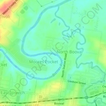
Name: North Booval topographic map, elevation, terrain.
Location: North Booval, Ipswich City, Queensland, Australia (-27.60968 152.77931 -27.58526 152.80309)
Average elevation: 59 ft
Minimum elevation: 3 ft
Maximum elevation: 167 ft
Make a donation
Gear up for your next adventure:
As an Amazon Associate, this site earns from qualifying purchases at no extra cost to you.
Other topographic maps
Click on a map to view its topography, its elevation and its terrain.
Make a donation
Gear up for your next adventure:
As an Amazon Associate, this site earns from qualifying purchases at no extra cost to you.
Flinders - Goolman Conservation Estate
Australia > Queensland > Ipswich City
Average elevation: 515 ft