Geolocate

Osburn topographic map

Click on the map to display elevation.

Osburn

Osburn is located at 47°30′23″N 116°0′20″W / 47.50639°N 116.00556°W / 47.50639; -116.00556 (47.506464, -116.005535), at an elevation of 2,520 feet (768 m) above sea level.

Wikipedia (CC-BY-SA 3.0)

About this map

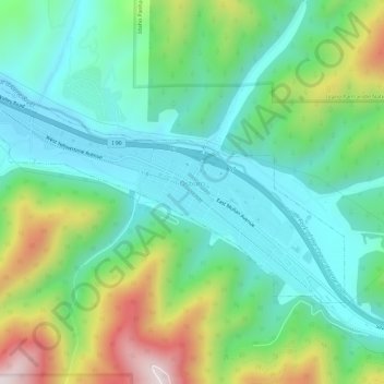
Name: Osburn topographic map, elevation, terrain.

Location: Osburn, Shoshone County, Idaho, 83849, United States (47.49356 -116.03497 47.51662 -115.97591)

Average elevation: 3,064 ft

Minimum elevation: 2,444 ft

Maximum elevation: 4,544 ft

Shoshone County trails, hiking, mountain biking, running and outdoor activities

Other topographic maps

Click on a map to view its topography, its elevation and its terrain.

Custer Peak

United States > Idaho > Shoshone County

Average elevation: 5,223 ft

Hoyt

United States > Idaho > Shoshone County

Average elevation: 3,219 ft

Devils Pulpit

United States > Idaho > Shoshone County

Average elevation: 3,661 ft

Canyon Peak

United States > Idaho > Shoshone County

Average elevation: 3,947 ft

McDonalds

United States > Idaho > Shoshone County > McDonalds

Average elevation: 5,551 ft

Pocono

United States > Idaho > Shoshone County

Average elevation: 2,936 ft

Gear up for your next adventure:

🧢Outdoor Hiking Hat - Sun protection hat for outdoor explorers
👟Trail Running Shoes - Lightweight shoes for trail runners
🥾Hiking Shoes - Durable and comfortable shoes for trail hiking
🏥Hiking First Aid Kits - Comprehensive medical kits for remote trail injuries
🧣Merino Neck Gaiters - Multi-functional headwear for wind and sun protection

As an Amazon Associate, this site earns from qualifying purchases at no extra cost to you.