Geolocate

Nelson topographic map

Click on the map to display elevation.

👉 Easily get elevation data in JSON, GeoTIFF and KML formats using Elevation API
Thank you for supporting this site ❤️
Make a donation

About this map

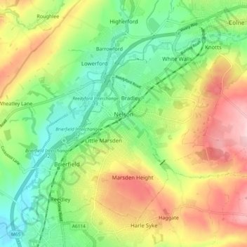
Name: Nelson topographic map, elevation, terrain.

Location: Nelson, Borough of Pendle, Lancashire, England, United Kingdom (53.81820 -2.23469 53.85045 -2.14182)

Average elevation: 607 ft

Minimum elevation: 299 ft

Maximum elevation: 1,024 ft

Other topographic maps

Click on a map to view its topography, its elevation and its terrain.

Pendle Hill

United Kingdom > England > Lancashire > Borough of Pendle

Average elevation: 1,263 ft

Trawden

United Kingdom > England > Lancashire > Borough of Pendle

Average elevation: 797 ft

Barley

United Kingdom > England > Lancashire > Borough of Pendle

Average elevation: 961 ft

Higham

United Kingdom > England > Lancashire > Borough of Pendle

Average elevation: 600 ft

Catlow

United Kingdom > England > Lancashire > Borough of Pendle > Nelson

Average elevation: 797 ft

Fence

United Kingdom > England > Lancashire > Borough of Pendle

Average elevation: 614 ft

Pendle Hill

United Kingdom > England > Lancashire > Borough of Pendle

Average elevation: 1,266 ft

Gear up for your next adventure:

🧦Merino Wool Socks - Moisture-wicking, blister-preventing socks for long treks
🔦LED Headlamp - Bright and durable LED headlamp for night navigation
👖Convertible Hiking Pants - Versatile zip-off pants for changing altitudes and temperatures
🎒Trail Energy Bars - High‑calorie bars for hiking energy
🎒Trekking Poles - Sturdy poles for balance and stability on rough terrain

As an Amazon Associate, this site earns from qualifying purchases at no extra cost to you.