
Make a donation
Gear up for your next adventure:
As an Amazon Associate, this site earns from qualifying purchases at no extra cost to you.
Klemskerke topographic map
Click on the map to display elevation.
Make a donation
Gear up for your next adventure:
As an Amazon Associate, this site earns from qualifying purchases at no extra cost to you.
Klemskerke
Klemskerke ligt in het West-Vlaams polderland op een hoogte van ongeveer 2 meter. Natuurgebieden zijn de Poldergraslanden tussen Klemskerke en Vlissegem.In het zuiden van dit landelijke dorp loopt de Noordede.
Make a donation
Gear up for your next adventure:
As an Amazon Associate, this site earns from qualifying purchases at no extra cost to you.
About this map
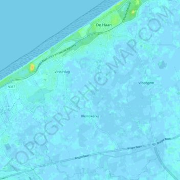
Name: Klemskerke topographic map, elevation, terrain.
Average elevation: 3 ft
Minimum elevation: -10 ft
Maximum elevation: 75 ft
Make a donation
Gear up for your next adventure:
As an Amazon Associate, this site earns from qualifying purchases at no extra cost to you.
Other topographic maps
Click on a map to view its topography, its elevation and its terrain.
Make a donation
Gear up for your next adventure:
As an Amazon Associate, this site earns from qualifying purchases at no extra cost to you.
Make a donation
Gear up for your next adventure:
As an Amazon Associate, this site earns from qualifying purchases at no extra cost to you.
Make a donation
Gear up for your next adventure:
As an Amazon Associate, this site earns from qualifying purchases at no extra cost to you.
De Meiboom
België > West-Vlaanderen > Oostende > Oudenburg > Roksem > De Meiboom
Average elevation: 20 ft