Geolocate

Cascade Range topographic map

Click on the map to display elevation.

About this map

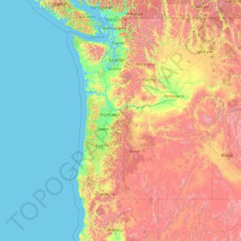
Name: Cascade Range topographic map, elevation, terrain.

Location: Cascade Range, Marion County, Oregon, USA (40.25228 -123.33252 49.65163 -119.56421)

Average elevation: 2,264 ft

Minimum elevation: -10 ft

Maximum elevation: 12,792 ft

Other topographic maps

Click on a map to view its topography, its elevation and its terrain.

Happy Valley

USA > Oregon > Happy Valley

Average elevation: 410 ft

Ochoco National Forest

USA > Oregon

Average elevation: 4,275 ft

Deschutes National Forest

USA > Oregon

Average elevation: 4,098 ft

Umatilla National Forest

USA > Oregon

Average elevation: 3,396 ft

Siletz Bay

USA > Oregon > Lincoln City

Average elevation: 16 ft

Siuslaw National Forest

USA > Oregon

Average elevation: 538 ft

Gear up for your next adventure:

📱Solar Portable Charger - Solar power bank for charging devices off‑grid
🗺️NatGeo Topo Maps - High-quality waterproof printed topographic maps of US Parks
Camping Coffee Makers - Enjoy premium coffee at the summit or campsite
🏕️Tent Footprint - Protect your tent base from wear
📡Handheld GPS Device - Reliable handheld GPS for outdoor navigation

As an Amazon Associate, this site earns from qualifying purchases at no extra cost to you.