Geolocate

Longview topographic map

Click on the map to display elevation.

About this map

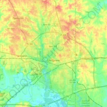
Name: Longview topographic map, elevation, terrain.

Location: Longview, Gregg County, Texas, United States (32.43153 -94.84434 32.58956 -94.66335)

Average elevation: 344 ft

Minimum elevation: 223 ft

Maximum elevation: 518 ft

Gregg County trails, hiking, mountain biking, running and outdoor activities

👉 Easily get elevation data in JSON, GeoTIFF and KML formats using Elevation API
Thank you for supporting this site ❤️
Make a donation

Gear up for your next adventure:

As an Amazon Associate, this site earns from qualifying purchases at no extra cost to you.

Other topographic maps

Click on a map to view its topography, its elevation and its terrain.

Liberty City

United States > Texas > Gregg County

Average elevation: 381 ft

Gladewater Park

United States > Texas > Gregg County

Average elevation: 322 ft

Gear up for your next adventure:

📦Dry Bags Set - Waterproof storage for electronics and clothes
🥾Hiking Shoes - Durable and comfortable shoes for trail hiking
📡Handheld GPS Device - Reliable handheld GPS for outdoor navigation

As an Amazon Associate, this site earns from qualifying purchases at no extra cost to you.