
Fruitland topographic map
Interactive map
Click on the map to display elevation.
About this map
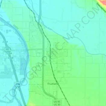
Name: Fruitland topographic map, elevation, terrain.
Location: Fruitland, Payette County, Idaho, 83619, United States (43.99614 -116.93684 44.05078 -116.90369)
Average elevation: 2,185 ft
Minimum elevation: 2,129 ft
Maximum elevation: 2,434 ft
Other topographic maps
Click on a map to view its topography, its elevation and its terrain.
New Plymouth
United States > Idaho > Payette County
New Plymouth, Payette County, Idaho, 83655, United States
Average elevation: 2,260 ft
Ontario Island
United States > Idaho > Payette County
Ontario Island, Payette County, Idaho, United States
Average elevation: 2,149 ft
Sand Hollow
United States > Idaho > Payette County
Sand Hollow, Payette County, Idaho, United States
Average elevation: 2,480 ft