
Make a donation
Gear up for your next adventure:
As an Amazon Associate, this site earns from qualifying purchases at no extra cost to you.
Ruthin topographic map
Click on the map to display elevation.
Make a donation
Gear up for your next adventure:
As an Amazon Associate, this site earns from qualifying purchases at no extra cost to you.
Ruthin
The Myddleton Arms is also known as the Seven Eyes. It is said to have been built in the 14th century. The Dutch style design, long, steeped roof is attributed to Sir Richard Clough, an Elizabethan merchant. It has four tiers of dormer windows, each at a different elevation, known locally as the seven eyes of Ruthin. The property was acquired in 1595 by Sir Hugh Myddleton, who provided London with it first fresh water supply. The view of The Myddleton on the square is in fact of the rear of the building. The front looks out over the Clwydian Hills.
Make a donation
Gear up for your next adventure:
As an Amazon Associate, this site earns from qualifying purchases at no extra cost to you.
About this map
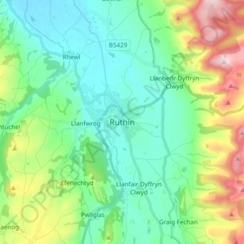
Name: Ruthin topographic map, elevation, terrain.
Location: Ruthin, Denbighshire, Wales, LL15 1BU, United Kingdom (53.07155 -3.34524 53.15155 -3.26524)
Average elevation: 531 ft
Minimum elevation: 115 ft
Maximum elevation: 1,657 ft
Make a donation
Gear up for your next adventure:
As an Amazon Associate, this site earns from qualifying purchases at no extra cost to you.
Other topographic maps
Click on a map to view its topography, its elevation and its terrain.
Make a donation
Gear up for your next adventure:
As an Amazon Associate, this site earns from qualifying purchases at no extra cost to you.
Make a donation
Gear up for your next adventure:
As an Amazon Associate, this site earns from qualifying purchases at no extra cost to you.
Clwydian Range and Dee Valley National Landscape
United Kingdom > Wales > Denbighshire
Separated by the Vale of Alyn, a second sister range, sometimes regarded (at least partly) as part of the Clwydian Range and included in the AONB since 2011, the Llantysilio and Maesyrchen Mountains, or South Clwyd Mountains extend further south to Acrefair and Gwyddelwern. Alongside the (core–northern)…
Average elevation: 545 ft
Coed Nant Simon
United Kingdom > Wales > Denbighshire > St Asaph > Llangwyfan
Average elevation: 692 ft
Make a donation
Gear up for your next adventure:
As an Amazon Associate, this site earns from qualifying purchases at no extra cost to you.
Coed Rhedyn-coch
United Kingdom > Wales > Denbighshire > St Asaph > Marian Cwm
Average elevation: 643 ft
Make a donation
Gear up for your next adventure:
As an Amazon Associate, this site earns from qualifying purchases at no extra cost to you.