Geolocate

Redan topographic map

Click on the map to display elevation.

About this map

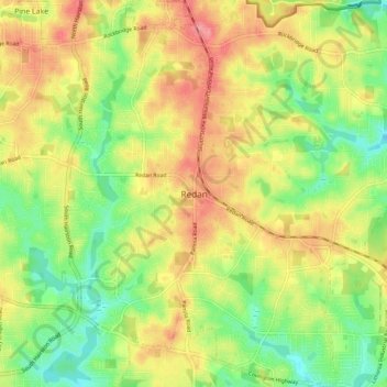
Name: Redan topographic map, elevation, terrain.

Location: Redan, DeKalb County, Georgia, 30088, United States (33.71588 -84.20553 33.79588 -84.12553)

Average elevation: 928 ft

Minimum elevation: 787 ft

Maximum elevation: 1,076 ft

DeKalb County trails, hiking, mountain biking, running and outdoor activities

Other topographic maps

Click on a map to view its topography, its elevation and its terrain.

Pine Lake

United States > Georgia > DeKalb County

Average elevation: 978 ft

Brook Run Park

United States > Georgia > DeKalb County > Dunwoody

Average elevation: 1,001 ft

Stone Mountain

United States > Georgia > DeKalb County

Average elevation: 1,001 ft

Doraville

United States > Georgia > DeKalb County

Average elevation: 1,007 ft

Gear up for your next adventure:

🖼️Topo Map Wall Art - Decorative topographic prints of famous peaks and regions
🎒Trail Energy Bars - High‑calorie bars for hiking energy
🏫Relief Map Kits - Hands-on tools for teaching landforms and elevation
📚Navigation Handbooks - Master the art of reading topographic maps and using a compass
🗺️Topographic Maps - Detailed topo maps for hiking, exploring and outdoor navigation

As an Amazon Associate, this site earns from qualifying purchases at no extra cost to you.