
Make a donation
Gear up for your next adventure:
As an Amazon Associate, this site earns from qualifying purchases at no extra cost to you.
Volaiville topographic map
Click on the map to display elevation.
Make a donation
Gear up for your next adventure:
As an Amazon Associate, this site earns from qualifying purchases at no extra cost to you.
About this map
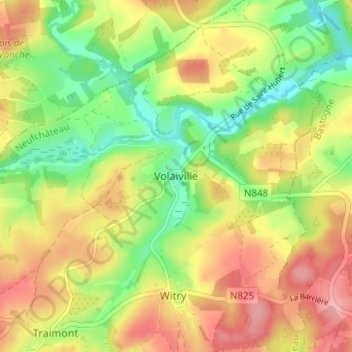
Name: Volaiville topographic map, elevation, terrain.
Location: Volaiville, Léglise, Neufchâteau, Luxembourg, Wallonie, Belgique (49.85249 5.59437 49.89249 5.63437)
Average elevation: 1,467 ft
Minimum elevation: 1,289 ft
Maximum elevation: 1,650 ft
Make a donation
Gear up for your next adventure:
As an Amazon Associate, this site earns from qualifying purchases at no extra cost to you.
Other topographic maps
Click on a map to view its topography, its elevation and its terrain.
Bouillon
Belgique > Luxembourg > Neufchâteau
Entourée de forêts, la ville s’étend dans et autour d’un méandre accentué de la Semois, un affluent de la Meuse. L'altitude y est d'environ 220 mètres. Elle est desservie par la route nationale 83 menant à Arlon, route qui borde la ville à l’est et qui se confond sur le territoire communal avec…
Average elevation: 1,122 ft
Saint-Hubert
Belgique > Luxembourg > Neufchâteau
Le Galata, altitude 589 m., point culminant de la commune est aussi celui du plateau de Saint-Hubert, un des « sommets » du massif (schisteux-rhénan) ardennais. Il se situe à l'est de la ville, au bord de la base aérienne EBSU. Il est accessible via le hameau de Hurtebise (monastère bénédictin), juste…
Average elevation: 1,480 ft
Make a donation
Gear up for your next adventure:
As an Amazon Associate, this site earns from qualifying purchases at no extra cost to you.
Parc national de la Vallée de la Semois
Belgique > Luxembourg > Neufchâteau
Average elevation: 1,158 ft
Make a donation
Gear up for your next adventure:
As an Amazon Associate, this site earns from qualifying purchases at no extra cost to you.
Make a donation
Gear up for your next adventure:
As an Amazon Associate, this site earns from qualifying purchases at no extra cost to you.
Make a donation
Gear up for your next adventure:
As an Amazon Associate, this site earns from qualifying purchases at no extra cost to you.
Make a donation
Gear up for your next adventure:
As an Amazon Associate, this site earns from qualifying purchases at no extra cost to you.
Make a donation
Gear up for your next adventure:
As an Amazon Associate, this site earns from qualifying purchases at no extra cost to you.
Make a donation
Gear up for your next adventure:
As an Amazon Associate, this site earns from qualifying purchases at no extra cost to you.
Make a donation
Gear up for your next adventure:
As an Amazon Associate, this site earns from qualifying purchases at no extra cost to you.
Make a donation
Gear up for your next adventure:
As an Amazon Associate, this site earns from qualifying purchases at no extra cost to you.
Make a donation
Gear up for your next adventure:
As an Amazon Associate, this site earns from qualifying purchases at no extra cost to you.
Make a donation
Gear up for your next adventure:
As an Amazon Associate, this site earns from qualifying purchases at no extra cost to you.
Make a donation
Gear up for your next adventure:
As an Amazon Associate, this site earns from qualifying purchases at no extra cost to you.
Make a donation
Gear up for your next adventure:
As an Amazon Associate, this site earns from qualifying purchases at no extra cost to you.
Make a donation
Gear up for your next adventure:
As an Amazon Associate, this site earns from qualifying purchases at no extra cost to you.
Make a donation
Gear up for your next adventure:
As an Amazon Associate, this site earns from qualifying purchases at no extra cost to you.
Make a donation
Gear up for your next adventure:
As an Amazon Associate, this site earns from qualifying purchases at no extra cost to you.
Make a donation
Gear up for your next adventure:
As an Amazon Associate, this site earns from qualifying purchases at no extra cost to you.
Réserve Naturelle des Anciennes Troufferies de Libin
Belgique > Luxembourg > Neufchâteau > Recogne
Average elevation: 1,440 ft
Make a donation
Gear up for your next adventure:
As an Amazon Associate, this site earns from qualifying purchases at no extra cost to you.
Make a donation
Gear up for your next adventure:
As an Amazon Associate, this site earns from qualifying purchases at no extra cost to you.
Make a donation
Gear up for your next adventure:
As an Amazon Associate, this site earns from qualifying purchases at no extra cost to you.
Make a donation
Gear up for your next adventure:
As an Amazon Associate, this site earns from qualifying purchases at no extra cost to you.
Make a donation
Gear up for your next adventure:
As an Amazon Associate, this site earns from qualifying purchases at no extra cost to you.
Make a donation
Gear up for your next adventure:
As an Amazon Associate, this site earns from qualifying purchases at no extra cost to you.
Make a donation
Gear up for your next adventure:
As an Amazon Associate, this site earns from qualifying purchases at no extra cost to you.
Bouillon
Belgique > Luxembourg > Neufchâteau
Entourée de forêts, la ville s’étend dans et autour d’un méandre accentué de la Semois, un affluent de la Meuse. L'altitude y est d'environ 220 mètres. Elle est desservie par la route nationale 83 menant à Arlon, route qui borde la ville à l’est et qui se confond sur le territoire communal avec…
Average elevation: 1,122 ft
Saint-Hubert
Belgique > Luxembourg > Neufchâteau
Le Galata, altitude 589 m., point culminant de la commune est aussi celui du plateau de Saint-Hubert, un des « sommets » du massif (schisteux-rhénan) ardennais. Il se situe à l'est de la ville, au bord de la base aérienne EBSU. Il est accessible via le hameau de Hurtebise (monastère bénédictin), juste…
Average elevation: 1,480 ft
Make a donation
Gear up for your next adventure:
As an Amazon Associate, this site earns from qualifying purchases at no extra cost to you.