
Bushley topographic map
Click on the map to display elevation.
About this map
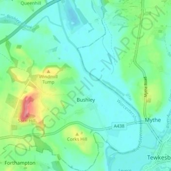
Name: Bushley topographic map, elevation, terrain.
Average elevation: 82 ft
Minimum elevation: 13 ft
Maximum elevation: 292 ft
Other topographic maps
Click on a map to view its topography, its elevation and its terrain.
Upper Broadheath
United Kingdom > England > Worcestershire > Malvern Hills > Crown East
Average elevation: 144 ft
Malvern
United Kingdom > England > Worcestershire > Malvern Hills
Malvern lies in the Lower Severn/Avon plain affording it a degree of shelter caused by virtue of its nestling in between the Cotswold hills to the east, the Welsh Hills and Mountains to the west, and Birmingham plateau to the north. Although as with all the British Isles it has a maritime climate, the local…
Average elevation: 312 ft
Kerswell Green
United Kingdom > England > Worcestershire > Malvern Hills > Kempsey
Average elevation: 82 ft
Corse Lawn
United Kingdom > England > Worcestershire > Malvern Hills > Eldersfield
Average elevation: 85 ft
Bastonford
United Kingdom > England > Worcestershire > Malvern Hills > Powick
Average elevation: 121 ft
The Hill, Abberley
United Kingdom > England > Worcestershire > Malvern Hills > Abberley
Average elevation: 433 ft
Elms Green
United Kingdom > England > Worcestershire > Malvern Hills > Abberley
Average elevation: 397 ft
Table Hill
United Kingdom > England > Worcestershire > Malvern Hills
Table Hill is situated in the range of Malvern Hills that runs about 13 kilometres (8 mi) north-south along the Herefordshire-Worcestershire border. It lies between North Hill and Sugarloaf Hill and has an elevation of 373 metres (1,224 ft).
Average elevation: 617 ft
Stonehall
United Kingdom > England > Worcestershire > Malvern Hills > Kempsey
Average elevation: 128 ft
Beach Hay
United Kingdom > England > Worcestershire > Malvern Hills > Bayton
Average elevation: 499 ft
Malvern
United Kingdom > England > Worcestershire > Malvern Hills
Malvern lies in the Lower Severn/Avon plain affording it a degree of shelter caused by virtue of its nestling in between the Cotswold hills to the east, the Welsh Hills and Mountains to the west, and Birmingham plateau to the north. Although as with all the British Isles it has a maritime climate, the local…
Average elevation: 312 ft
Worcestershire Beacon
United Kingdom > England > Worcestershire > Malvern Hills
Average elevation: 646 ft
Whiteacres
United Kingdom > England > Worcestershire > Malvern Hills > Powick
Average elevation: 89 ft
Malvern
United Kingdom > England > Worcestershire > Malvern Hills
Malvern lies in the Lower Severn/Avon plain affording it a degree of shelter caused by virtue of its nestling in between the Cotswold hills to the east, the Welsh Hills and Mountains to the west, and Birmingham plateau to the north. Although as with all the British Isles it has a maritime climate, the local…
Average elevation: 312 ft