Geolocate

Bomet topographic map

Click on the map to display elevation.

About this map

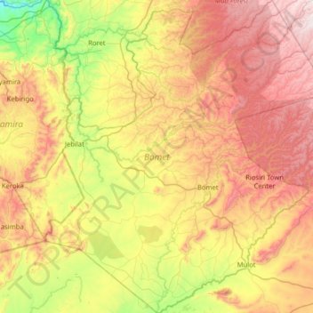
Name: Bomet topographic map, elevation, terrain.

Location: Bomet, Kenya (-1.03718 35.01294 -0.40156 35.58790)

Average elevation: 6,401 ft

Minimum elevation: 4,711 ft

Maximum elevation: 8,494 ft

Other topographic maps

Click on a map to view its topography, its elevation and its terrain.

Nyangores

Kenya > Bomet > Chepalungu

Average elevation: 6,227 ft

Gear up for your next adventure:

🛰️Handheld GPS Units - Professional satellite navigators for precise backcountry mapping
🍳Camping Cook Set - Complete cookware for outdoor meals
☀️Outdoor Sunscreen - High protection sunscreen for outdoor activities
📱Heavy-Duty Phone Cases - Drop-proof and waterproof protection for outdoor navigation
📷Action Camera - Capture your outdoor adventures in HD

As an Amazon Associate, this site earns from qualifying purchases at no extra cost to you.