Geolocate

Nairobi topographic map

Click on the map to display elevation.

About this map

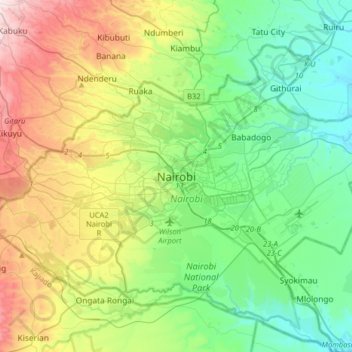
Name: Nairobi topographic map, elevation, terrain.

Location: Nairobi, 200, Kenya (-1.44325 36.65724 -1.12325 36.97724)

Average elevation: 5,656 ft

Minimum elevation: 4,921 ft

Maximum elevation: 7,313 ft

Gear up for your next adventure:

🕶️GPS Smartphone Mount - Secure mount for phone navigation
Backpacking Tent - Lightweight and durable tent for multi‑day hikes
💧Water Purification System - Clean water on the trail with reliable purifiers
🔌Solar Panel Charger - Charge gear sustainably outdoors
🧭Orienteering Set - Complete compass and map reading kit

As an Amazon Associate, this site earns from qualifying purchases at no extra cost to you.