
Thank you for supporting this site ❤️
Make a donation
Make a donation
Gear up for your next adventure:
As an Amazon Associate, this site earns from qualifying purchases at no extra cost to you.
Grad Trilj topographic map
Click on the map to display elevation.
Thank you for supporting this site ❤️
Make a donation
Make a donation
Gear up for your next adventure:
As an Amazon Associate, this site earns from qualifying purchases at no extra cost to you.
About this map
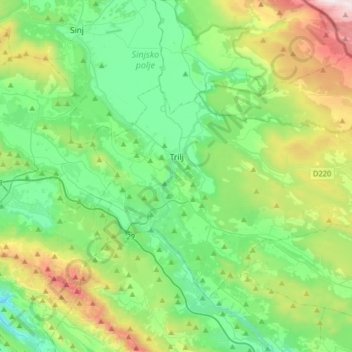
Name: Grad Trilj topographic map, elevation, terrain.
Location: Grad Trilj, Split-Dalmatia County, Croatia (43.52254 16.65049 43.68565 16.97617)
Average elevation: 1,745 ft
Minimum elevation: 203 ft
Maximum elevation: 5,873 ft
Thank you for supporting this site ❤️
Make a donation
Make a donation
Gear up for your next adventure:
As an Amazon Associate, this site earns from qualifying purchases at no extra cost to you.