
Make a donation
Gear up for your next adventure:
As an Amazon Associate, this site earns from qualifying purchases at no extra cost to you.
Samba topographic map
Click on the map to display elevation.
Make a donation
Gear up for your next adventure:
As an Amazon Associate, this site earns from qualifying purchases at no extra cost to you.
About this map
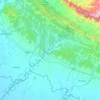
Name: Samba topographic map, elevation, terrain.
Location: Samba, Samba District, Jammu and Kashmir, India (32.40883 74.87638 32.74289 75.34265)
Average elevation: 1,516 ft
Minimum elevation: 896 ft
Maximum elevation: 5,971 ft
Make a donation
Gear up for your next adventure:
As an Amazon Associate, this site earns from qualifying purchases at no extra cost to you.
Other topographic maps
Click on a map to view its topography, its elevation and its terrain.
Nowshera
India > Jammu and Kashmir > Nowshehra Tehsil
Given its spatial and demographic extent, Nowshera has been given the status of a Sub-District. It is a beautiful place with a number of tourist attractions including the fort of Mangla Devi, holy cave temple of Mangla Mata, Central Gurudwara of Sikhs in Nonial, Qila Darhal and other Dargahs and temples. The…
Average elevation: 2,192 ft
Make a donation
Gear up for your next adventure:
As an Amazon Associate, this site earns from qualifying purchases at no extra cost to you.
Rajouri
India > Jammu and Kashmir > Rajauri
Rajouri is located at 33°23′N 74°18′E / 33.38°N 74.3°E / 33.38; 74.3. It has an average elevation of 915 metres (3001 feet).
Average elevation: 3,406 ft
Make a donation
Gear up for your next adventure:
As an Amazon Associate, this site earns from qualifying purchases at no extra cost to you.
Make a donation
Gear up for your next adventure:
As an Amazon Associate, this site earns from qualifying purchases at no extra cost to you.
Make a donation
Gear up for your next adventure:
As an Amazon Associate, this site earns from qualifying purchases at no extra cost to you.
Katra
India > Jammu and Kashmir > Reasi > Katra
Katra is located at 32°59′N 74°57′E / 32.98°N 74.95°E / 32.98; 74.95. It has an average elevation of 875 metres (2,474 feet). The Banganga River passes through the village.
Average elevation: 3,258 ft