Geolocate

Sublimity topographic map

Click on the map to display elevation.

About this map

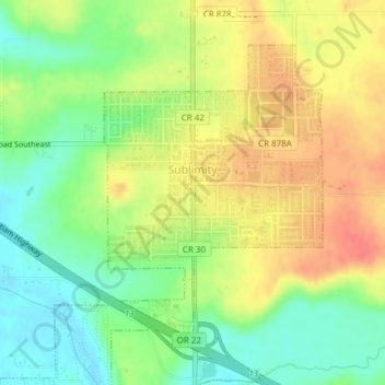
Name: Sublimity topographic map, elevation, terrain.

Location: Sublimity, Marion County, Oregon, United States (44.81755 -122.80346 44.83830 -122.78166)

Average elevation: 515 ft

Minimum elevation: 423 ft

Maximum elevation: 607 ft

Marion County trails, hiking, mountain biking, running and outdoor activities

Other topographic maps

Click on a map to view its topography, its elevation and its terrain.

Labish Center

United States > Oregon > Marion County

Average elevation: 167 ft

Brooks

United States > Oregon > Marion County

Average elevation: 180 ft

Fruitland

United States > Oregon > Marion County > Fruitland

Average elevation: 210 ft

Jawbone Flats

United States > Oregon > Marion County

Average elevation: 2,887 ft

West Stayton

United States > Oregon > Marion County

Average elevation: 381 ft

Gear up for your next adventure:

🛶Inflatable Kayak - Portable kayak for rivers, lakes, and expeditions
🪶Multi‑Purpose Knife - Useful blade for camp and trail
🧺Microfiber Travel Towels - Compact and fast-drying towels for trail use
👖Convertible Hiking Pants - Versatile zip-off pants for changing altitudes and temperatures
GPS Sports Watch - GPS watch for running, hiking and training

As an Amazon Associate, this site earns from qualifying purchases at no extra cost to you.