
Make a donation
Gear up for your next adventure:
As an Amazon Associate, this site earns from qualifying purchases at no extra cost to you.
Kürnach topographic map
Click on the map to display elevation.
Make a donation
Gear up for your next adventure:
As an Amazon Associate, this site earns from qualifying purchases at no extra cost to you.
Kürnach
Der Ort Kürnach liegt im bayerischen Regierungsbezirk Unterfranken, acht Kilometer nordöstlich von Würzburg und 25 Kilometer südwestlich von Schweinfurt. Die Gemeinde grenzt direkt an den Landkreis Kitzingen. Die Kürnach entspringt östlich der gleichnamigen Gemeinde. Sie fließt durch Estenfeld und Lengfeld, bis sie schließlich nach 11,6 Kilometer in die Pleichach mündet. Die mittlere Höhenlage beträgt 250 Meter über Normalnull.
Make a donation
Gear up for your next adventure:
As an Amazon Associate, this site earns from qualifying purchases at no extra cost to you.
About this map
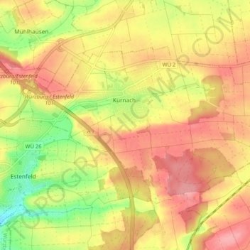
Name: Kürnach topographic map, elevation, terrain.
Location: Kürnach, Landkreis Würzburg, Bayern, 97273, Deutschland (49.82298 10.00715 49.85567 10.08772)
Average elevation: 906 ft
Minimum elevation: 705 ft
Maximum elevation: 1,043 ft
Make a donation
Gear up for your next adventure:
As an Amazon Associate, this site earns from qualifying purchases at no extra cost to you.
Other topographic maps
Click on a map to view its topography, its elevation and its terrain.
Make a donation
Gear up for your next adventure:
As an Amazon Associate, this site earns from qualifying purchases at no extra cost to you.
Make a donation
Gear up for your next adventure:
As an Amazon Associate, this site earns from qualifying purchases at no extra cost to you.
Maidbronn
Deutschland > Bayern > Landkreis Würzburg
Die Bundesautobahn 7 begrenzt im Wesentlichen die Gemarkungen an der östlichen Grenze. Nach Süden hin läuft die Gemarkungsgrenze auf dem Höhenzug entlang, über die Höhe 304 zwischen Estenfeld und Maidbronn, vorbei am Versbacher Breitholz (Eichig), bis zum Dreimarker Rimpar-Versbach-Maidbronn. Von da an…
Average elevation: 902 ft
Make a donation
Gear up for your next adventure:
As an Amazon Associate, this site earns from qualifying purchases at no extra cost to you.
Make a donation
Gear up for your next adventure:
As an Amazon Associate, this site earns from qualifying purchases at no extra cost to you.
Hausen bei Würzburg
Deutschland > Bayern > Landkreis Würzburg > Hausen b. Würzburg
Average elevation: 974 ft
Goßmannsdorf
Deutschland > Bayern > Landkreis Würzburg > Ochsenfurt
Vom 14. bis ins 19. Jahrhundert hatte der Ort eine geschlossene Dorfbefestigung, die aus einer Ringmauer mit drei großen und sieben kleinen Türmen bestand. Sie ist nur noch teilweise in ihrer alten Höhe erhalten.
Average elevation: 807 ft
Make a donation
Gear up for your next adventure:
As an Amazon Associate, this site earns from qualifying purchases at no extra cost to you.
Make a donation
Gear up for your next adventure:
As an Amazon Associate, this site earns from qualifying purchases at no extra cost to you.