Geolocate

Devizes topographic map

Click on the map to display elevation.

About this map

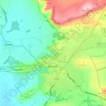
Name: Devizes topographic map, elevation, terrain.

Location: Devizes, Wiltshire, England, United Kingdom (51.33304 -2.02588 51.38514 -1.96327)

Average elevation: 387 ft

Minimum elevation: 190 ft

Maximum elevation: 791 ft

Other topographic maps

Click on a map to view its topography, its elevation and its terrain.

Eysey

United Kingdom > England > Wiltshire > Cricklade

Average elevation: 266 ft

Reybridge

United Kingdom > England > Wiltshire > Lacock

Average elevation: 213 ft

West Kennett

United Kingdom > England > Wiltshire

Average elevation: 571 ft

Jugg's Wood

United Kingdom > England > Wiltshire > Froxfield

Average elevation: 430 ft

Hawkeridge

United Kingdom > England > Wiltshire > Hawkeridge

Average elevation: 187 ft

Deptford

United Kingdom > England > Wiltshire > Wylye > Deptford

Average elevation: 361 ft

Hippenscombe

United Kingdom > England > Wiltshire

Average elevation: 702 ft

Botley Hill

United Kingdom > England > Wiltshire

Average elevation: 584 ft

Nomansland

United Kingdom > England > Wiltshire

Average elevation: 223 ft

Gear up for your next adventure:

🧭Orienteering Set - Complete compass and map reading kit
🪶Trail Camera - Capture wildlife on your hikes
🔥Fast-Boil Camping Stoves - Efficient cooking systems for quick trail meals
🎒Gear Packing Cubes - Organize your backpack efficiently
🧼Biodegradable Camping Soap - Eco‑friendly soap for outdoor hygiene

As an Amazon Associate, this site earns from qualifying purchases at no extra cost to you.