
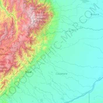
Paz de Ariporo topographic map
Interactive map
Click on the map to display elevation.
About this map
Name: Paz de Ariporo topographic map, elevation, terrain.
Location: Paz de Ariporo, Casanare, Colombia (5.41637 -72.04817 6.12649 -69.82649)
Average elevation: 2,956 ft
Minimum elevation: 354 ft
Maximum elevation: 17,241 ft
Other topographic maps
Click on a map to view its topography, its elevation and its terrain.
San Francisco
San Francisco, Recetor, Casanare, Colombia
Average elevation: 4,800 ft
Villanueva
Colombia > Casanare > SAN JOSE BUBUY
Villanueva, SAN JOSE BUBUY, Casanare, Colombia
Average elevation: 771 ft