
Schneckengrün topographic map
Interactive map
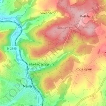
Click on the map to display elevation.
About this map
Name: Schneckengrün topographic map, elevation, terrain.
Average elevation: 1,883 ft
Minimum elevation: 1,591 ft
Maximum elevation: 2,165 ft
Other topographic maps
Click on a map to view its topography, its elevation and its terrain.
Döbrastöcken
Deutschland > Bayern > Landkreis Hof > Naila
Döbrastöcken, Naila, Landkreis Hof, Bayern, 95131, Deutschland
Average elevation: 2,119 ft
Lippertsgrün
Deutschland > Bayern > Landkreis Hof > Naila > Lippertsgrün
Lippertsgrün, Naila, Landkreis Hof, Bayern, 95119, Deutschland
Average elevation: 2,077 ft
Linden
Deutschland > Bayern > Landkreis Hof > Naila > Linden
Linden, Naila, Landkreis Hof, Bayern, 95119, Deutschland
Average elevation: 1,827 ft
Marlesreuth
Deutschland > Bayern > Landkreis Hof > Naila
Marlesreuth, Naila, Landkreis Hof, Bayern, 95119, Deutschland
Average elevation: 1,952 ft