Geolocate

Winkler topographic map

Click on the map to display elevation.

About this map

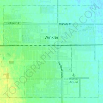
Name: Winkler topographic map, elevation, terrain.

Location: Winkler, Manitoba, Canada (49.16277 -97.97220 49.19991 -97.90878)

Average elevation: 892 ft

Minimum elevation: 873 ft

Maximum elevation: 932 ft

Gear up for your next adventure:

🧥Waterproof Jacket for Hiking - Breathable and rugged rain jacket for outdoor excursions
🧢Outdoor Hiking Hat - Sun protection hat for outdoor explorers
🗻Climbing Gear Basics - Essential gear for beginner climbers
🎒Hydration Pack - Hands‑free water reservoir for long hikes
🥘Titanium Cookware - Durable, featherlight pots and pans for backpacking

As an Amazon Associate, this site earns from qualifying purchases at no extra cost to you.