Geolocate

Cuba topographic map

Click on the map to display elevation.

About this map

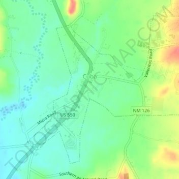
Name: Cuba topographic map, elevation, terrain.

Location: Cuba, Sandoval County, New Mexico, United States (36.00860 -106.97021 36.03122 -106.93650)

Average elevation: 6,929 ft

Minimum elevation: 6,854 ft

Maximum elevation: 7,070 ft

Sandoval County trails, hiking, mountain biking, running and outdoor activities

Other topographic maps

Click on a map to view its topography, its elevation and its terrain.

Seven Springs

United States > New Mexico > Sandoval County

Average elevation: 8,327 ft

La Cueva

United States > New Mexico > Sandoval County

Average elevation: 8,104 ft

Placitas

United States > New Mexico > Sandoval County

Average elevation: 6,115 ft

San Luis

United States > New Mexico > Sandoval County

Average elevation: 6,296 ft

Redondo Peak

United States > New Mexico > Sandoval County

Average elevation: 10,476 ft

Placitas

United States > New Mexico > Sandoval County

Average elevation: 6,115 ft

Cabezon

United States > New Mexico > Sandoval County

Average elevation: 6,194 ft

Gear up for your next adventure:

🧦Hiking Socks - Comfortable socks to prevent blisters on long hikes
🥤Water Filter Bottle - All‑in‑one filter bottle for safe hydration
🪶Fire Starter Kit - Reliable fire starter for survival and camping
🚁Photography Drones - Capture stunning aerial views of landforms and topography
👓Polarized Sunglasses - Outdoor sunglasses for glare reduction

As an Amazon Associate, this site earns from qualifying purchases at no extra cost to you.