
Cabezon topographic map
Click on the map to display elevation.
About this map
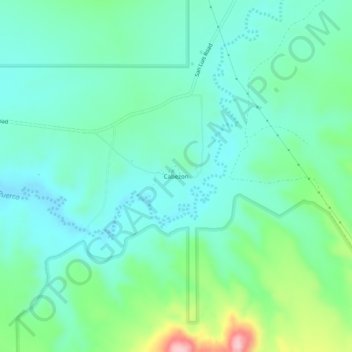
Name: Cabezon topographic map, elevation, terrain.
Location: Cabezon, Sandoval County, New Mexico, United States (35.60617 -107.11971 35.64617 -107.07971)
Average elevation: 6,194 ft
Minimum elevation: 6,017 ft
Maximum elevation: 6,765 ft
Other topographic maps
Click on a map to view its topography, its elevation and its terrain.
Rio Rancho
United States > New Mexico > Sandoval County
Rio Rancho is in an arid climate due to its location in the rain shadow of the Sandia Mountains to the east and the Continental Divide to the west. Rio Rancho receives 8.90 inches of precipitation annually on average. The western portion of the city receives slightly more rain and snowfall due to its higher…
Average elevation: 5,486 ft
Rio Rancho
United States > New Mexico > Sandoval County
Rio Rancho is in an arid climate due to its location in the rain shadow of the Sandia Mountains to the east and the Continental Divide to the west. Rio Rancho receives 8.90 inches (226 mm) of precipitation annually on average. The western portion of the city receives slightly more rain and snowfall due to its…
Average elevation: 5,486 ft
Rio Rancho
United States > New Mexico > Sandoval County
Rio Rancho is in an arid climate due to its location in the rain shadow of the Sandia Mountains to the east and the Continental Divide to the west. Rio Rancho receives 8.90 inches of precipitation annually on average. The western portion of the city receives slightly more rain and snowfall due to its higher…
Average elevation: 5,486 ft