
Make a donation
Gear up for your next adventure:
As an Amazon Associate, this site earns from qualifying purchases at no extra cost to you.
Silver Springs topographic map
Click on the map to display elevation.
Make a donation
Gear up for your next adventure:
As an Amazon Associate, this site earns from qualifying purchases at no extra cost to you.
About this map
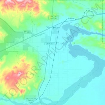
Name: Silver Springs topographic map, elevation, terrain.
Location: Silver Springs, Lyon County, Nevada, 89429, United States (39.28661 -119.32496 39.46040 -119.11810)
Average elevation: 4,482 ft
Minimum elevation: 4,121 ft
Maximum elevation: 6,115 ft
Lyon County trails, hiking, mountain biking, running and outdoor activities
Make a donation
Gear up for your next adventure:
As an Amazon Associate, this site earns from qualifying purchases at no extra cost to you.
Other topographic maps
Click on a map to view its topography, its elevation and its terrain.
Mound House
United States > Nevada > Lyon County
Mound House is a small unincorporated community in Lyon County, Nevada on U.S. Route 50 that is situated between Nevada's capital, Carson City, and Dayton. Its elevation is 4,974 feet (1,516 m). It is in Lyon County, one of eight Nevada counties that allow for legalized prostitution, and is home to four…
Average elevation: 4,990 ft
Make a donation
Gear up for your next adventure:
As an Amazon Associate, this site earns from qualifying purchases at no extra cost to you.